I wrote most of this up before the events of day 7 changed everything when Pat Hadley fell to her death on Diamond North peak. I have hiked and scrambled a number of peaks with her and appreciated many more of her trip reports and I am pretty upset about this loss. She was one of the most energetic, enthusiastic, and positive people I have been with and she is sorely missed by many. Before this happened I was planning on doing Day 10 too, but the remainder of the challenge was cancelled after this tragedy.
I was busy working on my place trying to get things I had to do done so the work could continue, so I couldn't do all the days. I decided one day would be allowable, so Sunday the 18th I joined with a bunch of others for a 4am start from Lake Sabrina.
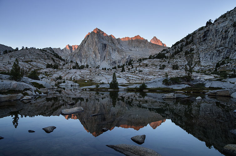
We started off in the dark at a decent but reasonable pace and we made decent time up through the dark woods. I turned off my headlamp around Dingleberry lake as the sky began to get light. We passed a photographer with tripod and slr set up by a little lake getting pics of Picture Peak - I zipped over to snap a few myself. Unfortunately for him some clouds obscured the alpenglow shortly after this.
| |
|---|
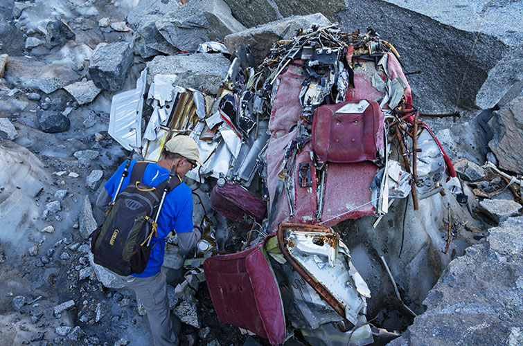
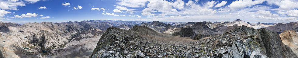
A little before Hungry Packer Lake we took off cross country passing more lakes and talus fields on our way up to Echo Col. The glacier here was in pretty sad shape but it did reveal most of a pretty recent airplane crash - recent as in the last 30 years or so. Then we scrambled up the loose rocks to Echo Col where we were met with the first rays of the sun. From there we could see our destination off in the distance - Black Divide in between Black Giant and Mount McDuffie. It looked like going up Black Giant on the way there might be a good plan, so Sean and I traversed around to the right while the rest of the crew dropped down past some lakes to LeConte Canyon. We weren't entirely sure that our route would go, but it did with some talus, slabs, and more talus. We saw some other hikers on the JMT when we got there, but shortly we headed back cross country towards Black Giant.
 |
|---|
 |
|---|
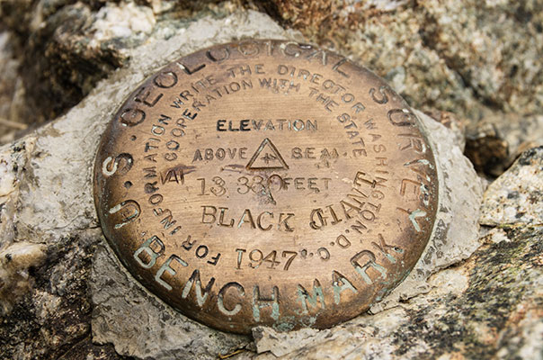
I headed up to the ridge on Black Giant way to soon and had to do some scrambling up and down along the ridge up past a number of false summits to the actual summit. I got there just before 11 am. From there I traversed down the ridge scrambling down a steep notch before climbing back up the ridge to the summit of Black Divide. I got there just as most of the rest of the crew were departing down to the west. The weather was looking a little ominous, so I soon followed them. Lots of loose rock descending and then it was time to head back up over a pass to the JMT. At 1:14 the first thunder boomed. By the time I got to the pass it was quite close - about a second between the flash and the boom. I was tired and wanted to move slowly, but I forced myself over the pass quickly and then put on my raincoat as the graupel started. I was dismayed to see - not a gentle descent to the JMT, but another basin to cross. I couldn't tell if maintaining altitude would cliff me out, so I dropped down into this basin. The rain stopped and I filled up with much needed water and then trudged back up out of the basin - here I was passed by Sean who had continued on to Mt McDuffie - he claimed he was out of shape, but he still passed me easily. From the top of this rise it was a gentle descent to the JMT and then I returned the way I came in side hilling back to Echo Col. I was going much more slowly and the return of the rain and lightning did not help, especially for the slabs. Finally I made it to the last scree ascent up to Echo Col and saw Michael ahead of me - he was just behind me to the summit of Black Divide, and although he was not moving fast, he was still faster than I was. I was really dragging at this point - not too surprising considering I was 13 hours into things and many thousands of feet of elevation gain.
 |
|---|
 |
|---|
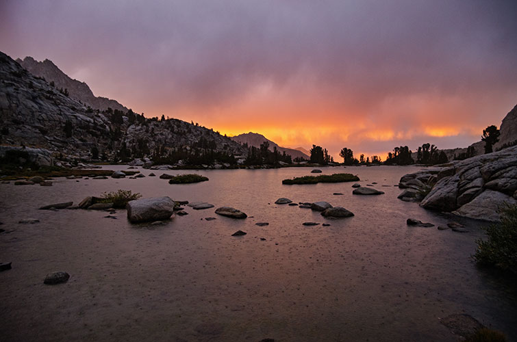
I finally made it up over the pass at 5:30. oof. The descent was treacherous and slow, followed by seemingly endless talus before some meadows and use trails past Echo Lake. By this time it was pretty dark, and it started sprinkling yet again. It seemed pretty light though, so I let myself get pretty wet before I decided it was serious and put on my raincoat. At this point I had followed the wrong use trail and it ended in a heap of car sized talus. I hopped across that for a while to another use trail that ended at a lake - not one I wanted to be at though. Because the rain was picking up I didn't want to pull out my map, so I just headed off bushwhacking in what I thought was the correct direction. This got me to another lake with some nice sunset light coming under the clouds ahead lighting up Mt Emerson and the Piute Crags. The rain was also picking up. I went around this lake and continued bushwhacking on. I found about 50 feet of decent trail, but it went to a river crossing and disappeared. I bushwhacked on - eventually needing my headlamp to determine if where I was trying to step was dry land or not.
 |
|---|
After nearly an hour of thrashing down canyons and through wet brush I finally hit the trail - it was 8:20, dark, raining, and I had been going for over 16 hours. I headed off down the trail with only a short bit of panic and indecision as it went uphill much more than I liked. At least I generated more heat on the uphills - it wasn't that cold, but it wasn't warm either and I didn't want to stop to put on more insulation. At this point I was able to move more rapidly again as I was on a trail and using my trekking poles to help balance and determine how far steps were. Unfortunately my fix wasn't entirely working and I suffered from SPCS (Sudden Pole Collapse Syndrome) far too often. The trail tried to lose me in a few places by crossing blank slabs or making switchbacks without warning but I was not fooled for long. Unfortunately with all this moisture the trail seemed to have stretched out a lot. Finally I saw a light ahead - way ahead. It took ages to hike past the lake and the dam, but finally I made it back to the trailhead at 10:35 - 18.5 hours since we started. I was pretty wet and tired. I drove back to Bishop where it had rained and my solar shower was no longer warm. I drank a bunch of lemonade and went to bed.
Later Michael told me his GPS said he went 30 miles this day - he probably hiked a bit farther than I did - at least before my scenic route in the evening- but I did Black Giant too. Also somewhere after he pulled ahead of me on Black Giant and when he did McDuffie (the peak S. of Black Divide) Sean slipped and when he caught himself he broke his 5th metacarpal bone (in his hand proximal to the pinky).
 |
|---|