Tom Grundy's Rainier 2009 Travels Page
this trip report is mostly final now, but I am sure I'll add a few pics and fix a few things and add more links later
It seems a brutal sufferfest has become a yearly yogaslacker tradition now that it has happened more than once. This year was no exception and Andy concocted another big one in the hopes that it would make him happy to sit at a desk for the rest of the year. The plan was to climb up one side of Mount Rainier, ski down the other, packraft out the White River to the bicycles stashed at Buckley, and bicycle back to the car. As usual, things did not go as planned. For starters the weather was a bit iffy and there was a lot of fresh snow. Then we discovered the west side road in the park was closed. The chosen route up was changed to the Success Cleaver, with the distinction of being the longest route on the mountain.
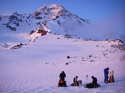
Andy, Jason, and Chelsey planning Success Cleaver
 |
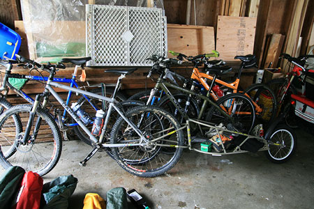
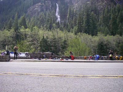
bicycles stashed in the garage
 |
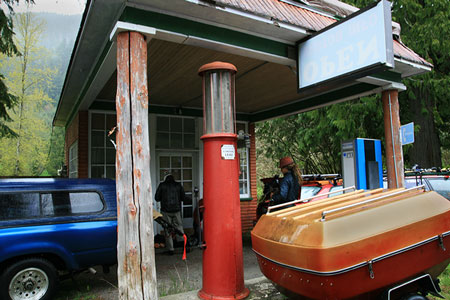
We met up in Buckley and stashed the bikes at a very kind friend of a friend's and drove on to Longmire in the park. There we paid our peak fees and got our permit. Then we started sorting and prepping and packing gear under an old gas station bay which provided some protection from the rain which had been falling most of the day. We had come from all over, Andy flew in from N Dakota. I had been at Smith Rock and drove up from Portland that morning to pick him up at the Airport. Sam drove all the way from North Dakota in a marathon of sleep deprivation. Jason and Chelsey drove up from California, but had just come from Costa Rica. We were all veterans of last year's Montana trip except for Chelsey, she had been hanging out with Jason long enough that she sort of knew what she was getting into - exhausted, scared, cold, wet, and even more exhausted. But exactly how much none of us really knew. Eventually we thought we had all the food and gear ready (some of this was gear we were just getting for the first time - always exciting to go on a serious expedition with new gear). The packs weighed in somewhere around 35 pounds which is pretty light considering they included alpine touring ski and whitewater boating gear. Some of the weight savings were in one ultra lightweight 3 person tent and 2 sleeping bags for the 5 of us along with packrafts and inflatable PFD's (life jackets) for the river. We set the alarm and slept in our vehicles listening to the rain and hoping the forecast break in the weather materialized.
packing under an old gas station overhang
 |
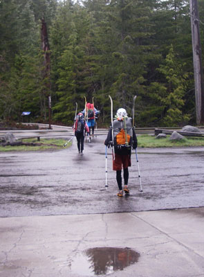
Starting up the trail
 |
Day 1 (May 14, 2009)
The morning was gray and dreary and we filled up water bottles and made our final preparations. Then we had to take off our warm clothes and head up the trail.
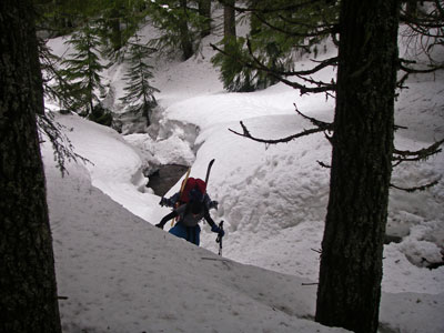
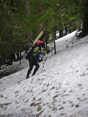
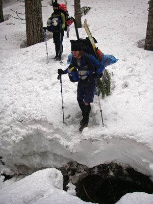
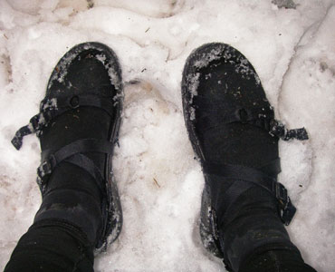
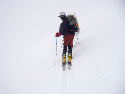
The closed road (not open for the summer yet) meant we ended up starting at the Kautz Creek trailhead at around 2400 feet of elevation in a drizzle. Soon we were hiking on snow in sneakers for everyone but me who was in sandals and wetsuit socks. All of our feet were cold. Eventually we lost the trail in the snow and after a rather exciting stream crossing we decided it was time to start skiing. Our feet thanked us at first, especially mine, as the ski boots were a lot warmer - the blisters and blood would come later. We were using dynafit bindings and 130 cm skis with skins to go uphill. The skins stick to the bottom and have hairs pointing backwards that keep the skis from sliding and allowed us to shuffle uphill as long as it wasn't too steep.
Crossing the Kautz creek channel
 |
Andy after a stream crossing
 |
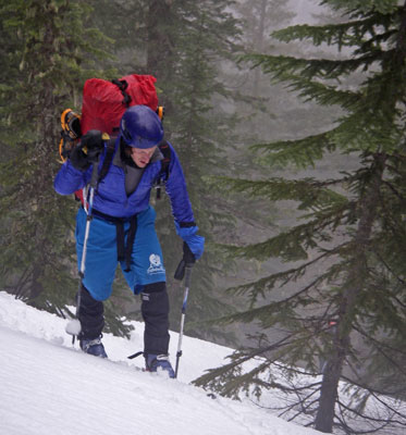
Chelsey hiking on the snow
 |
Jason psyches up for a stream crossing
 |
My footwear was less than optimal
 |
Sam puts on his skis
 |
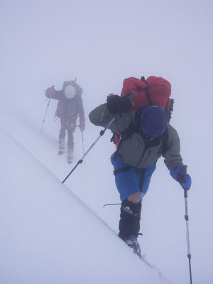
As we got higher the snowfall picked up and the visibility decreased. Route finding got a little more interesting, but by a combination of map and compass reading and dead reckoning we actually spotted the buried cabin along our route. Once we approached tree line things got a little harder. For the leader visibility was almost zero with the slight texture of the snow fading into the surrounding whiteout as little as 3 feet in front of your skis. The rest of us were able to see the tracks and the person in front for orientation. It was incredibly taxing leading as it was hard to tell the slope let alone where you were supposed to go. We dodged around cliffs and steep slopes and eventually decided we were near the pyramid peak saddle. From there we dropped down to the saddle and started up the Success Cleaver ridge. At least the route finding was a lot easier here, just head uphill the easiest way you could find.
Chelsey skiing up a slope
 |
Andy skiing up through the trees
 |
Things got snowier
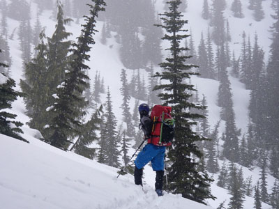 |
We started getting whiteout conditions around tree line
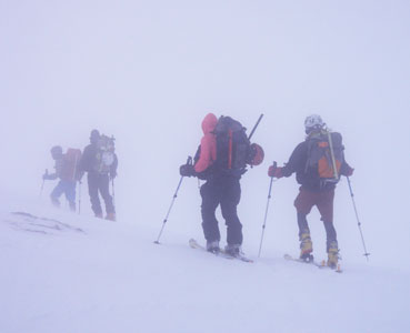 |
Sam and others in the whitout
 |
rime ice on a pine and ghost skiers
 |
it was very disorienting
 |
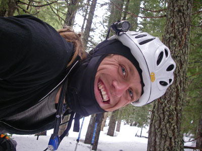
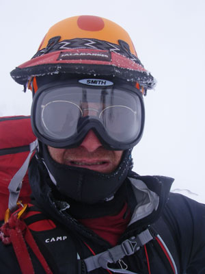
Tom self portrait - lovely conditions
 |
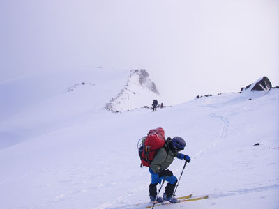
We continued on uphill using the altimeter to navigate and just as we were approaching a planned camping spot the cloud level dropped enough to reveal the upper mountain and a little later we were treated to a view of Mount St. Helens as well. As the sun went down, we set up camp here digging into the snow and constructing a wall as a windblock. The CAMP XLS shovels worked well for moving the snow, and the paddles worked well for cutting it. Not the usual combination for mountaineering, but if you are carrying it you might as well use it.
Finally visibility increased around 8000 ft
 |
Where we camped the first night
 |
When we went to start cooking we discovered we had no matches or lighter (we had discussed this while packing but somehow didn't rectify the situation). Sam had a flint and we were able to start the stove with sparks. That night we had tasty dried Indian food with butter (one of the advantages of cold weather camping). Then we got to test out our minimalist sleeping accomodations. As I mentioned we had a three person tent and 2 sleeping bags for five of us. This sounds worse than it was, but not by much. For starters the tent was a warmlight model that had an incredible amount of space for it's weight. It was larger than most 3 person tents I've seen. Besides, we wanted to be packed in tight for warmth, and we were packed in tight. Sam, Andy, and I were under a 2 person "bag" that didn't have a bottom. Jason and Chelsey were under a similar one person arrangement. If 2 of us were on our sides we could barely get the edges of the bag down to the ground. Jason and Chelsey weren't so lucky, but if they were wedged next to us, we didn't need to get the sides between us down to the ground. That brings me to the ground - or should I say the snow. Immediately under the sil-nylon floor was the snow. The pads we had were very lightweight and sort of had an hourglass of inflatable insulation to cover your shoulders and hips if you could stay on them. Our feet were mostly fine in ski boot liners, but it seemed that whatever position I was in there was always some part of me touching and being frozen by the snow. In addition my rehydration plans were wildly successful resulting in multiple trips outside to relieve myself. The lights of Seattle and Portland looked nice at night, but I'd have preferred to sleep. Luckily we were planning an early start, as I didn't get much sleep, maybe half an hour.
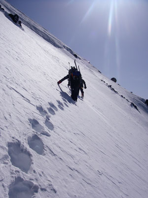
Day 2 (May 15, 2009)
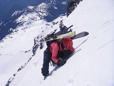
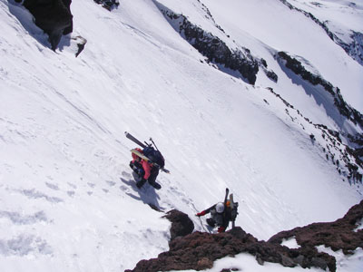
We got up at 4 the next morning and packed up in the mostly dark (there was some moonlight and the sky was starting to get brighter). By the time we started moving at 5 it was light enough to navigate with no problems. Up the ridge we went sometimes post-holing in the snow or scraping on the rocks, but usually sinking in at least a few inches. It was tiring going but we made decent time until the slope steepened. Then things slowed down a bit more. After heading up the ridge for ages and ages it looked like the upper headwall was no closer. We couldn't really tell where the route went, but eventually there was a vertical cliff on the ridge so we traversed out to the right onto the steep snow slopes and followed a weaving path up towards a couloir that looked promising. It was here that we probably passed some of the steepest climbing - maybe 50 degrees or so of rather unconsolidated snow that required kicking multiple steps to get down to something that might hold you up. It was slow and exhausting going. I had been sharing leading duty with Jason and Andy up through here, but after this I just didn't have the speed to make it worth my while to kick steps much more. Luckily they had the energy to continue leading (luck has nothing to do with it, they put in the training effort, but the rest of us were lucky to have them on the trip).
Kicking steps up the steep snow
 |
it was quite tiring
 |
but Andy kept us going
 |
Chelsey on the steep, with ridge behind
 |
We gave Andy and Jason the rest of our water and they continued on up the couloir while the rest of us stopped to melt some snow on a small ledge. Then we plodded on up after them stopping to put on crampons where things got a bit icier. There was another reprieve where the angle lessened as we went around another corner to the right, but soon we were heading up another 45 degree snow slope. By now the sun was low and we were heading into the shade and cold. In addition Sam was feeling the altitude (as were we all, huffing and puffing for precious oxygen). This snow slope continued for ages, but finally we were able to turn a corner to the left to the final lower angled slopes to the summit of Point Success. Unfortunately when we turned that corner we were met with a brutal freezing 30 mph headwind that sucked any remaining heat out of us. We put on some more clothes in a slightly sheltered area behind a rock and contemplated our situation. We were all exhausted and cold and the wind was brutal not to mention the altitude (over 13000 feet). Things could rapidly turn into a survival situation. Luckily up to the right there was a 25 degree snow slope somewhat protected by 2 small cliffs, so we started to dig in there with the hand shovels and paddles. Eventually we had a platform just barely big enough for the tent and we crawled inside. This time we put a few of the boats and empty packs down under us so that we wouldn't be sleeping almost directly on the snow. This helped a lot, and although there were still some cold spots under me, they weren't icy. Our planned schedule had us summitting and skiing down the other side this day, but the difficult snow conditions combined with the route finding kept us from that goal. Luckily we had enough extra fuel to continue to melt snow and cook food.
Day 3 (May 16, 2009)
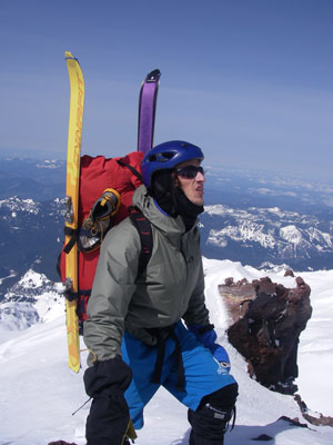
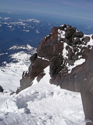
We weren't in any rush the next morning because we didn't want to hit the skiing until it was a bit softer. This allowed me to get a few hours of sleep, and when I got out to start melting snow we would have been in the sun if a lenticular cloud wasn't forming starting at our position. Once again the views were spectacular to the South I could see Mt Adams and Hood, and I think Jefferson. I melted snow until the stove sputtered to a stop out of fuel.There was one bit of steep snow around a rock up to the final snow slope to Point Success at 14,158 feet. I dug a small hole here and waited out of the wind while Andy headed on to the true summit. Sam and I skied a bit from here but the icy slope up to the summit thwarted us. The wind was whipping over the summit and forming a haze of clouds that rushed by just a few feet above us. Eventually we got up to Columbia Crest, the true summit of Rainier at 14,410 feet. The way we had come up was much more difficult than my previous ascents via the Disappointment Cleaver. Carrying boating gear didn't help either. From the summit we tromped across the crater to the East and over the rim onto the Emmons Glacier, the largest Glacier in the contiguous US with around 4 square miles of ice.
The last of the steep snow after camp
 |
The platform we camped on
 |
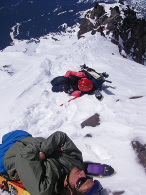
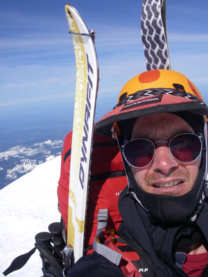
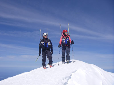
Tom on Point Success
 |
Jason and Chelsey on Point Success
 |
As I was packing up my crampons I tried to straighten them so I could compact them and snapped the connecting bar. One of the disadvantages of ultralightweight gear. We put on our skis with trepidation (or possibly terror on my part). It was steep, and got steeper below us. At first the skis were iced up and barely slid, but that didn't last long. We traversed to the left to avoid the steepest slope below us. As we got down a bit we could see that it was blue ice dropping off below. Yikes. What we were on at the time was a mix of hard wind blasted snow and partly icy wind blasted snow with a few patches of less consolidated snow. I managed a few turns, but then blew one and slid for a bit. In addition my ski leash broke free (I had a relatively weak one because supposedly you want it to break in case of avalanche). I was more worried about losing my ski than an avalanche up here, so I tied it up more securely while slowly sliding down the slope. Meanwhile Jason chased an escaped paddle shaft down to the lip of a serac and the others forced a path down through the steepest part. By now I was getting down with a mix of traversing, side slipping, and kick turns.
Skiing down the Emmons Glacier
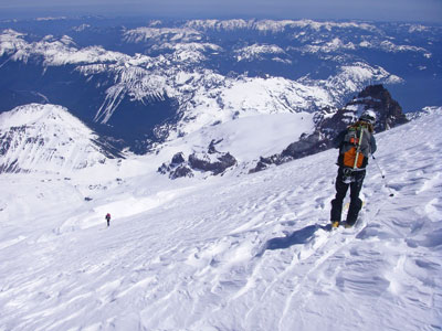 |
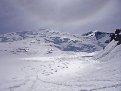
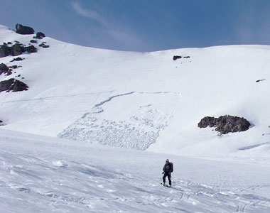
Our thighs were completely tired by the time we got off of the steepest part of the slope and had pieced together a path through the ice-fall and crevasses (They were for the most part completely buried under the massive snowfall). Now we were getting more patches of soft snow under a crust and even some softer slushy snow. This was very grippy and if you weren't leaning back when you hit it would often result in a face-plant. I think we all had at least one spectacular rag-doll crash. Sam and I had many of them, but I think he had the most spectacular with 5 somersaults up high on the mountain. When we got near Camp Sherman around 9,600 feet we took a break to let our thighs recover and planned our next move up over Steamboat Ridge to the Inter Glacier. We skied down a bit then put on skins and started angling up. The snow was very soft here on the south slope and a slab avalanche started ahead and below Andy who was in the lead. We retreated and re-assessed. We could try to climb up the slope by the rocks, or up by Camp Sherman and head down the Winthrop Glacier towards the West Fork of the White River, or the choice we finally took, to continue down the Emmons Glacier. This was a lot more fun and forgiving skiing, but also thigh destroying soft snow. With a little bit of careful side hilling we were able to ski down to around 5000 ft before we had to put on the skins to continue.
Ski trails on the Emmons Glacier
 |
YIKES - the avalanche
 |
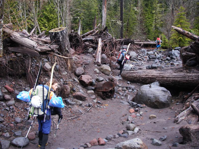
From here we followed the valley looking for the trail on the N side. Eventually after backtracking around a lake we saw a bit of a trail in a clear patch with no snow. The others took off their ski boots here, but since my alternative was sandals with frozen wet suit socks, I kept the ski boots on. We played hide and seek with the trail marked with "caution" tape for ages. Mostly we were on the snow but there were a few clear stream crossings and rocky patches. Finally we found the main trail and followed that down to the White River campground. This was closed, but at least we knew we were getting closer to our goal for the day. The road had been partly cleared up to the campground, so I took off the skins and was able to slide down the "groomed" road here. We passed a heavily laden group of climbers heading up to climb Liberty Ridge. Soon after that we found a nice new climbing rope in the middle of the road. Sam ran it back up the trail to them and was able to get some matches from them.
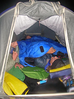
We camped on the asphalt where there was a bridge over the White River at around 4,000 feet. This was as far as the road was cleared. We cooked on a small fire and were able dry out some of the gear. It was also a bit warmer sleeping although still crowded.
room for one more in the tent?
 |
Day 4 (May 17, 2009)
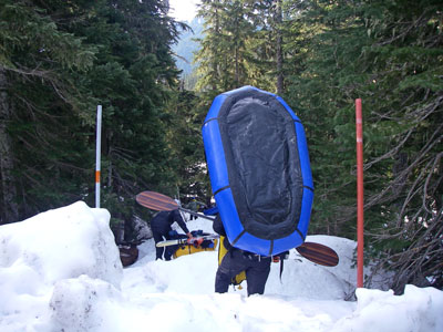
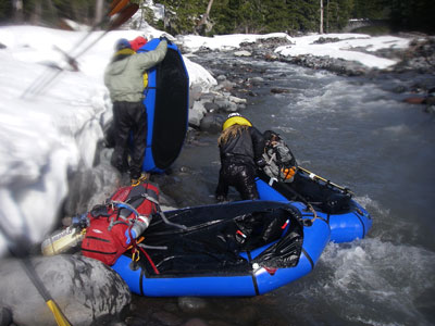
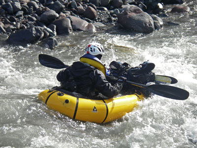
The next morning it took a while to get the pack rafting stuff ready. We were using Alpacka pack rafts which pack amazingly small and light and make this kind of crazy trip possible.Getting the skis all strapped on took a fair amount of fiddling. It was also hard to take off and pack our warm clothing and put on the wet and cold stuff for the river. Eventually we were ready and post-holed through the snow to the White River. The river was running fast over gravel and cobbles and a bit of bedrock between walls of snow. We put in and headed down. The water was cold. Very cold. Luckily the sun was warm. Soon we had to get out to scout a blind turn. Then for the first of many strainers. A strainer is something across the river that lets the water through, but maybe not a raft or person. They can be quite dangerous in a current. Washington is the "Evergreen State", and it seemed they were all in the river blocking our way. Sometimes we could go almost a KM, but sometimes less than 100 M. It was very frustrating. Also often you could see the next strainer after walking around the one you stopped for. At one point Sam just kept carrying his boat along while those who stopped and started were keeping about the same pace. You went very fast in the river, but getting in and out as well as hoisting the boat was very slow and exhausting. Chelsey could barely lift her soaked pack which didn't help at all.
This looks like a good place to paddle
 |
Early on the river - dumping out water
 |
Chelsey and Jason on the river
 |
Jason paddles downstream
 |
We took a stop and decided we needed to pick up the pace for log strainers. People re-arranged packs for easier carrying and we took some weight out of Chelsey's pack so she could lift it. After that our pace picked up a bit, but it was still slow going with so many logs. The other thing that slowed us was getting stuck in a shallow channel of the braided river. The advantage of the braided channels was that if there was a strainer, often one of the other channels would be clear. Another thing that would happen is that you would brush a cobble and it would roll up onto others and suddenly you would be sitting on a rock much higher than anything you saw ahead. You could also hear the rocks rolling and grinding under the water in the rapids.
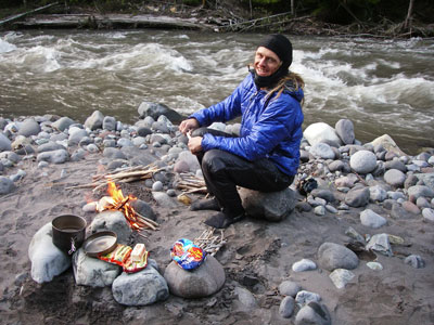
By now most of the snow was left behind and it would have been quite hot had we not been in and out of the still frigid water. One cool thing we saw was the ducks swimming down some pretty serious whitewater. I think they were harlequin ducks, and they were bobbing through waves at least 3 times as tall as them. We also saw plenty of moose tracks while portaging. Later in the afternoon we saw some people on the shore, which was quite a surprise to us. We decided to stop before we lost the sun so that we could dry things a bit. After a few rounds of some pretty serious class III in a bit of a gorge, we passed under a bridge and found a gravel bar in the sun. There the gear explosion occurred and we got things out to dry, created a somewhat flat tent platform, and set up a cooking fire and a drying fire.
That night we ate the last of our non-bar foods, 3 packs of ramen (one a big Korean one) and a stick of butter. It was delicious and I could have eaten it all myself instead of splitting it 5 ways. I bet the others felt the same way, especially Sam, who doesn't have much in the way of fat reserves and was becoming unable to stomach bars (they made him gag). We sat around the fire staying warm and drying stuff for a while before wedging into the tent one last time.
Sam is excited to cook 3 ramen with butter for 5
 |
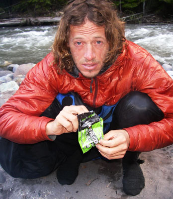
Jason is exhausted, Day 5 morning
 |
Day 5 (May 18, 2009)
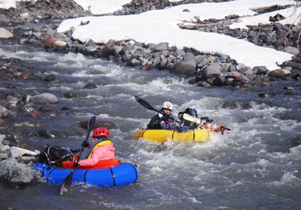
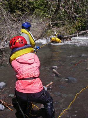
The next morning I rebuilt the fire and we used it to warm up the wet clothes we had to put on for paddling. By the time the sun reached us, we were ready to move. Off we went around the corner and took out for another strainer. The river was a lot deeper and there were some bigger rapids too. This was fun for running it, but a lot scarier for the strainers. Things continued like this for a bit, and I managed to flip in a hole and swim a bit. The good news is the inflatable life jackets work. It was very cold, but hoisting my boat and pack onto my head helped keep me warm enough. Then Jason blew an exit before a strainer (something we had all done at one time or another, as the steep cobble banks and fast moving water was treacherous). Unfortunately he lost his paddle and raft and they went into the strainer. The raft got stuck and the paddle disappeared.
Jason went in search of the paddle while Andy and Chelsey held the throw rope and Sam climbed the tree towards the stuck boat. I stood by in my boat ready to chase the boat down should it break free. I went after the sleeping pad when it got washed out, but it quickly wound up on another strainer before I could get to it. I was able to get to this one from the shore though.
trying to free the stuck raft attempt 1
 |
Sam tied the rope onto the raft and we started pulling, but it wouldn't budge, so he let some air out. That looked like it was working until the rope came clear. Eventually he managed to clear it with the rope tied on and they pulled it to shore. Still no paddle though. Sam went up to an overlook on the road (for looking at Skookum Falls) and returned saying it was 3 miles to Greenwater. He also had a bag with some chicken legs and potato salad (donated by kindly tourists). We devoured them, then moved our gear up to the overlook and started drying and repacking. We tried hitchhiking without much luck, but an off-duty highway patrol man out for a bike ride stopped by and said he'd call in to see if the patroller could take some of us on to Buckley, or at least closer. Soon a patroller did stop and after frisking them, gave a ride to Andy, Jason, and Chelsey to Buckley and the bicycles. Sam and I were left with the gear. We talked to people and enjoyed the kindness of strangers who fed us (thank you very much everyone). Then we had everything packed up and we got a ride with the gear to Buckley. All this kindness from strangers really reconfirmed our faith in humanity.
packing gear at the falls pullout
 |
From there we went to the grocery store and got some ice cream and chocolate milk to revive Sam. Meanwhile the others were hammering out 60 miles on the bikes in a fast pace line. They were doing great 'til it started raining. Then the spray from the bicycle in front was a pain, not to mention the cold. Eventually they got to the cars and headed back. Meanwhile Sam and I crashed on the garage floor. We were woken up by their return and groggily related our separate paths. Then I drove Andy to the airport where he had missed his flight but was determined to get onto the next one he could. I dropped him off around 1 am and drove back to crash in the back of the truck.
The next morning our repacking and sorting was hampered by the occasional shower, but then Jason and Chelsey headed off to Seattle to return a borrowed bike and Sam and I headed South to Portland.
Although the trip didn't go as planned and we didn't succeed in all of our goals, we still probably got the FPRA (first pack raft ascent) of Rainier (what other idiots would take a boat over this big of a mountain?), and skied the Emmons Glacier and paddled a lot of the White River. I lost a mitten somewhere on the mountain and broke a crampon. Andy lost a paddle, and I'm sure all of the boats got a lot of scraping on the bottom as we went down the shallow braided channels.
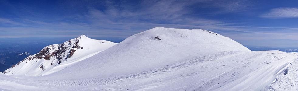
Panoramic image of the Liberty Cap and Rainier Summit (Columbia Crest) from Point Success
 |
Many more pictures can be seen on the Yogaslacker gallery here:
Yogaslacker Rainier Gallery
A similar (written by me) but different pictures story is blogged on the Yogaslacker blog...
Yogaslacker blog on Rainier trip
They also have a page with the Spot tracker info here (aerial photo or map with track on it):
Yogaslacker Spot tracker adventure on Rainier trip
a Yogaslacker Rainier trip video on Youtube
a Yogaslacker Rainier trip slideshow video on Youtube
It will get blogged elsewehere probably, and eventually end up in WEND magazine we hope.