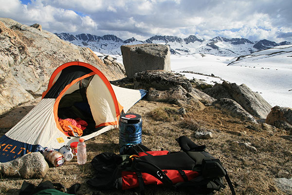
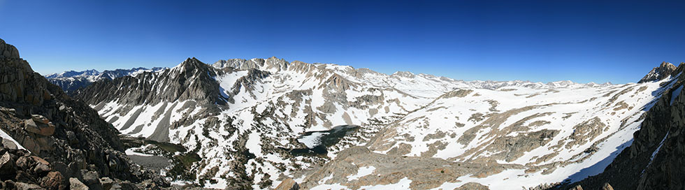
Once again I headed back into the mountains. This time I went in from North Lake over Piute Pass for 4 nights in the Humphreys Basin area. The weather forecast wasn't for 100% sun, so I took a bivy tent. Unfortunately I forgot to refill my stove before the trip, but luckily most of the food I had could be eaten without cooking.
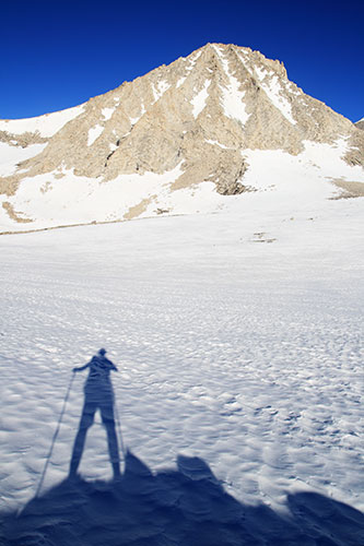
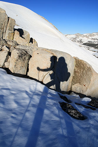
From North Lake I had to hike quite a bit of road because you aren't allowed to park at the concession campground at the actual trailhead. (In case you can't tell, I am not a big fan of concessions running our land for profit and lobbying for laws to keep us from camping anywhere near them). The trail followed the North Fork of Bishop Creek which was rushing right along. Some of it looked like it would be fun to packraft, but other bits went through low hanging branches or over little waterfalls. I lost the trail for a bit as it went up a hill towards Loch Leven, but for the most part it was melted out until quite close to the pass. Once over the pass I turned right and headed deeper into the Humphreys Basin. I foolishly (but somewhat entertainingly) went down a nearly vertical snow scarp at the top of a slope. I probably slipped about 15 feet, but I figured that with the pretty soft snow and clean runout I was ok. Still, I should have traversed a few hundred feet to a lower angled section that I couldn't see from above. As the afternoon wore on the snow got softer and my progress slowed. I found a nice flat spot, but there weren't any great wind blocks around. Luckily I had enough bagels and peanut butter and brownies that I wasn't planning on cooking for dinner anyway. That night the precipitation started.
| |
|---|
 |
|---|
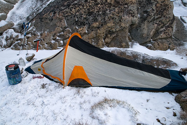
I couldn't really tell what was hitting the tent, but it turns out it was small snow pellets. In the morning it was still hitting the tent, so I just stayed bundled up and read and worked x-word puzzles. Finally it looked like it might think about clearing up and my bladder couldn't take it anymore so I got out. It turns out that nothing was actually falling from the sky anymore, it was just blowing along the ground. I think there was about 2 inches from the night before, but it wasn't distributed evenly. I packed up my gear for the day and headed north out of the wind. As expected it was easy to travel on the snow which was good, because some of the rocks had a slick of ice on them and were treacherous. I tromped up to one high point (over 12,750 ft) and looked around from the summit. Then I headed a bit NE towards another high point. It turns out this was Four Gables - at 12,720 ft and really just a bump on a ridge that was neither the highest point along it or the most impressive looking I was unsure why it got the name and the summit register. By now it was partly clear above and most of the snow that was going to blow around down below had done so. I headed N along the ridge down to a col and then up to another peak that you can see looking up the Horton drainage between Mt Tom and Basin Mountain. This was a much more impressive peak and it is higher at something over 12,800 feet. From here I was forced to decide if I wanted to try to continue on towards Mt. Tom or return. I opted for the return because although Mt. Tom has a most excellent name and it looked cool I didn't fancy having to reverse all the up and down it would require, especially if the snow got really soft later in the afternoon. After returning to the Four Gables peak area I traversed along the ridge to a much more impressive point at 12,888 feet or so. From there I dropped back down and headed back to camp.By now the snow wasn't always much fun to walk on, but I still got back around 4 and had to make another decision.
 |
|---|
My options were to kick back and stay here another night or move camp. Kicking back might have been the easy way, but it wouldn't be the Yogaslacker way. I packed up camp and headed off NW towards French Canyon. This was slow going as now with the full pack I was post-holing regularly. It took a lot of effort to slog up to the ridgeline and then drop down into the next little basin. Finally I stopped near the outlet from Steelhead Lake. As I was setting up camp it started to snow again. This was a pain because I was hoping to dry my gear out instead of squeezing into a little bivy shelter with it. There wasn't any real accumulation, just enough to keep me holed up.
I planned to get an early start the next morning, but I didn't wake up quite as early as I planned (5:30 instead of maybe 4:45). Still I was on the move before 6 tromping quickly over the now frozen snow. I had one stream crossing at the start of French Canyon that was easy on the frozen solid snow bridges, but I spent a bit of time making sure there was a way to return when things were softer. From there I had to tromp uphill and across some large expanses of snow. I was glad it was still hard.
 |
|---|
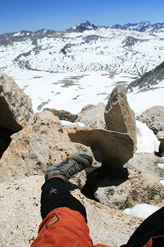
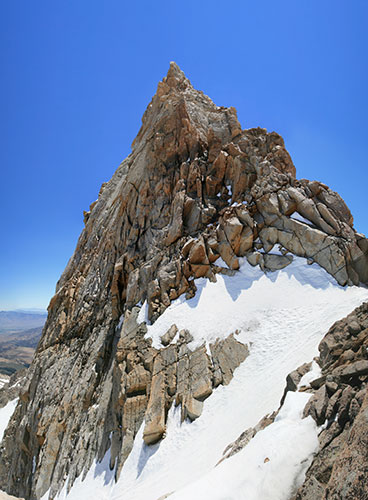
The first objective of the day was Merriam Peak. I put on the crampons and headed up a broad snowfield on the SE side to the ridge. It was fairly steep at the top, but not so steep that I wasn't able to just keep walking up with the crampons. At first it was easy going along the ridge but when it turned to the east it got quite ridgy and I was forced to climb on one side or the other. Still, there was nothing but time and being a bit tired keeping me from the 13,103 foot summit. From there I dropped down to the north to the col between Merriam and Royce Peak and started up Royce. This was mostly just a talus slog and I was hoping to hit the summit by noon. I didn't make it, but I did get to the summit plateau. I climbed the middle and N high points (the middle was the higher one at 13,282 feet) and poked around looking for a summit register but I couldn't find any. Then I had to decide if I should press on and try for Feather Peak or return back to the South. I decided to go for it and scrambled down towards the Royce-Feather Col. This had some real scrambling as well as steep snowfields to cross. I should have put on the crampons for that as it was still a little sketchy with a thin layer of new soft snow over some pretty hard old snow. Still, it looked like a manageable runout and I never slid far. From the col I traversed over a bit and then started climbing up. I climbed a few 4th class bits but with some more clever route finding and snow travel I probably could have kept it to 3rd class. Still I wasn't really looking forward to the return. The 13,240 foot summit of Feather had a very satisfying drop off on the N and E sides. I relaxed a bit and enjoyed a celebratory fat stick and avoided thinking about my descent.
 |
|---|
 |
|---|
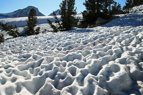
Soon it was time to go and I decided to investigate a couloir on the north side of the peak. This looked promising so I put on the crampons and took out my snow axe and put on my mittens and started down. For the steepest part I faced in and kicked steps and stuck the shaft of my axe in for security. Once the angle lessened I kick stepped a bit and then started glissading. It sure beat carefully downclimbing the way I came up. Once I was out of the couloir I cut to the south under the steep E faces of Feather and Royce. There I cut SE back towards my camp. There was a ridge that was relatively snow free and I vaguely followed that although sometimes it was easier to stay on the snow even though it was pretty soft. Finally the rock ran out and I was stuck with the soft snow. Not only was it soft, but the sun cups were pretty grim with ridges and holes up to about knee deep. It was definitely a slog now. I dropped down and crossed the creek at a spot where I could see the water under the snow was pretty shallow (so even if I plunged through I wouldn't drop into a pool or waterfall). From there it was a long slow uphill slog back to camp. At least once I got there I was able to spread things out to dry and bask in the remaining sun and the successful objectives for the day. I also fired up the stove to cook dinner, as my bagel supply was running low.
 |
|---|
 |
|---|
The morning of my 4th day I once again tried to get moving early to take advantage of the cold hard snow. Unfortunately that meant packing up the shelter with ice still in it. I tromped back towards Mount Humphreys and traversed mostly on the snow below its northern spur. I was trying to find a route that would take me up to the NW side of the summit spur. I probably spent a fair bit of time a little above where the easiest travel would be, but I don't like to drop down a lot of elevation when I am planning on going up. Eventually I settled on a likely looking gully and stashed my sleeping and food gear and started scrambling up. It looked pretty impassible but there were actually plenty of hand and footholds. One of the keys was to stay out of the bottom of the drainage where the holds were all rounded. After the initial steep bit I found myself in a long lower angled talus shoot. From the top of that an easy traverse brought me to the notch below the final summit spur. The view down to the east was quite nice, and the NE face was most impressive.
 |
|---|
 |
|---|
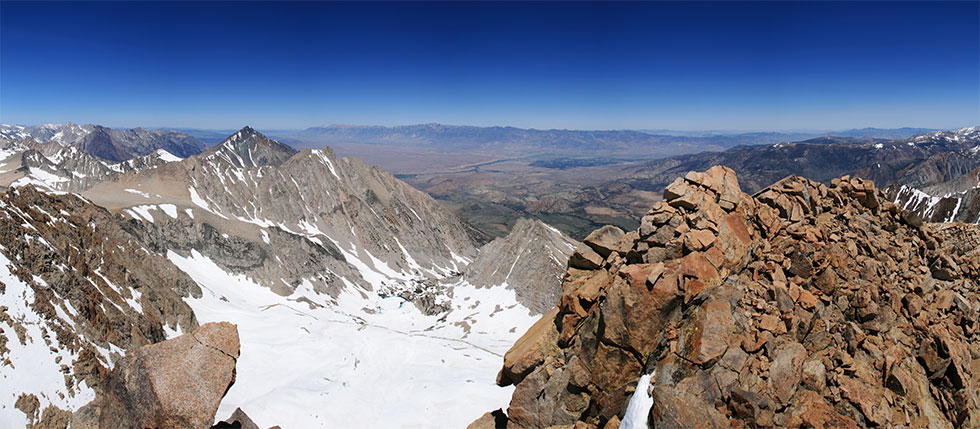
I only had a vague description of how to get up, so I mostly just went whichever way looked ok. At first it was pretty easy, but then I had to cut left and then back right past a piton and up to the actual ridge. Then back right past a rappel anchor and finally right again to easier ground up to the 13,986 foot summit. I was disappointed to see the little dinosaur that was up here when I came up from the east side in 2006 was nowhere to be seen. Still, the view was mighty spectacular in all directions (this is the highest peak in the immediate area). I had good cell reception up here so I called to let my parents know I was ok (although I still had to make the descent). I also read through the summit register and enjoyed the view. There was a nice seat out of the wind looking down over the Buttermilks and the Owens Valley so I relaxed for a bit. I picked a slightly easier variation on the descent and soon I was back at the stuff I had stashed in the notch. I was also able to follow the talus gulley down farther on the main descent. Finally I made it back to the rest of my stuff.
 |
|---|
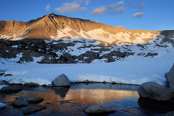
By now the snow was pretty soft so travel on it was a bit slower and I tried to stick to the talus when I could. I basically traversed to the south looking for a decent camp spot a little closer to tomorrows objectives. I had to explore a number of rock "islands" before I found a flat spot. There I spread everything out to dry. I stretched a bit and read before cooking dinner and crawling into my bag. It was a lot warmer this night and I had to take off even more layers.
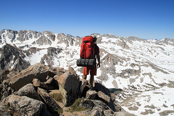
For my last day I cooked breakfast for once, and my fuel held out. Then I traversed along the slope to the south and east looking for a way to get up the western edge of Mount Emerson. I had to put on my crampons when I was traversing steeper snow. Finally I found a way up on the SW side. There was a bit of climbing at first but then it was just a lot of talus. I was going slower than I had on some of my other trips because I was carrying my full pack. I reached the western summit but it was really just the western end of a long ridge and there was clearly a higher summit to the east. The traverse wasn't too hard, but I had to drop down on the south side a few times to get around teeth and I decided not to try to go up the west side of the final summit but instead drop back down and circle around to the south side. There wasn't a lot of wind today and for the first time it actually felt hot even up at this altitude. The 13,204 ft summit had a nice seat facing east so I spent a bit of time there reading the summit register. As usual it was nice to see people I knew in there. It seems the south ridge and face are popular routes up this peak.
 |
|---|
When it was time for descending I made a rather large tactical mistake (maybe). I say maybe because the way I went down wasn't very good, but without real knowledge of any other way I can't say for sure that they would have been better. In any case I dropped down to the SE into a wide gully with a few snowfields. I avoided the snowfields and stuck to the rock when I could because the loose scree and talus was quite loose and although it can be quick to boot ski and plunge step down in those conditions it also destroys your boots and fills them up with sand and gravel. Not to mention that the chance of falling is considerable and with a full pack not a pleasant option. So I slowly picked my way down to the contact with some metamorphic rocks. I was hoping for some cool skarn minerals and easier travel but I was disappointed on both counts. Soon the chute turned right and narrowed alarmingly. It was still relatively easy going, just slow and tedious and the canyon was getting narrow too, limiting the area available to search for decent travel. Then I hit a steep patch of snow that filled the bottom of the gulley. I should have put on the crampons for the 30 feet, but instead I plotted a safe slide path and when I did slide, I followed that for 10 feet to a good stopping point. Things got even dicier with a small waterfall (there was flowing water in the gulley) dropping down behind and under another bigger snowfield. I was able to scramble around the waterfall on the side but then I had to put on my crampons on a tiny sloped ledge and the edge of the steep snow - complicated by the fact that it is always a little scary standing on the edge of the snow because it is hard to tell how much of the edge is melted out underneath. Once I was fully on the snow it was pretty easy going although somewhat tense because I didn't always know how deep the snow was or if there was a melted cavity underneath. Then I came to another little waterfall where the snow was completely melted out. If I knew the snow was deep and strong I could have just jumped the few feet, but I didn't know, so off came the crampons and I did a bit of sketchy traversing with both my crampons and walking sticks hanging from my wrists. Finally I was able to ease back onto the snow and get the crampons on. One of the most frustrating things about this whole descent route was that at any time I could have come upon an impassible cliff or other obstacle and had to reverse my way back up this horrendous loose chute to find another way down. This last snowfield took me out of the tight chute and onto the open talus below the cliffs. From here it was smooth sailing back to the Piute Pass trail. I think under the right snow conditions this gulley would have been pretty mellow, or with no snow I am guessing it would have been ok but unpleasant - I am not sure though, there could have easily been a 10 foot cliff under the snow. In any case if I go that way again, I will head down south and west of the summit towards Loch Leven.
It was pretty easy going once I got back on the trail and I made good time. Unfortunately I was heading down into mosquito territory, especially as I passed the campground and went down the road past some flooded meadows. Back at the truck I wedged everything back in and headed down towards the hot lowlands. Once again I was able to wash off in the very bracing - and flowing hard - McGree Creek.
 |
|---|