Tom Grundy's Mount Gabb, Mount Hilgard, and Mount Abbot Page
6-18 to 21, 2020 We had planned this trip a few weeks earlier, but the rather alarming forecast (lows in the teens with snow and 50 + mph winds) convinced us to head to the Inyos instead. The forecast for this weekend was much more favorable. We didn't really know what the snow levels were, but correctly assumed that there would be some snow travel up high but that most of the basins would be mostly snow free. This is a low snow year.
We had the usual dilemma of what gear to bring but settled on taking 2 of Iris' packs and the big bear cannister plus ice axes and crampons. This added a few pounds and some bulk to our kit but also kept us more legal and provided storage for the many sandwiches we packed. My pack was around 32 lbs - not counting trekking poles or my camera. As usual packing and getting to the trailhead took longer than we wanted. In fact we didn't start hiking from Mosquito Flat until nearly 8:20 pm. Fortunately at this time of year the days are long. We hiked in on the trail and camped near Gem Lakes as it was really getting dark. Dinner was sandwiches. I think there were a few mosquitos but also a breeze and they weren't a problem.
6-19-2020, we didn't get up particularly early and had a breakfast of quick steel cut oats and tea before packing up and heading up the "trail" which didn't go where we wanted to, so we backtracked to a use trail that soon left us on talus and snow. The snow was the easier travel option since it was still cold enough to stay on top and there weren't very many or deep sun cups.
Dade Lake was nearly entirely snow and ice covered and above that it was pretty much just rock and snow. We went up to the ridge up towards N Col and put on our crampons before heading up the steeper snowfield to the right of it. Things were starting to get softer but it was still pretty good conditions. We ended up on the rock ridge for a while before another steep snowfield up to the col (which is really just a slightly lower spot in the ridge to the north of Cox Col). The snow conditions got worse near the top with a few post holing events where my foot sunk in to my knee or deeper. By now we were over 13,000 feet and Iris in particular was really feeling the altitude with being out of breath and not moving very fast. I wasn't a whole lot better in the speed department, but didn't feel as out of breath. There was at least one party on the N Ridge of Bear Creek Spire that we saw and heard from time to time.
Iris heading up a snowfield towards the ridge to N Col
Dade Lake below her, Mt Morgan on the right
 |
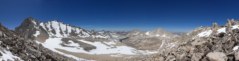
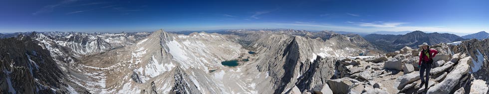
panorama looking west from near N Col with Bear Creek Spire on the left, Lake Italy center, Hilgard and then Gabb to the right of that
 |
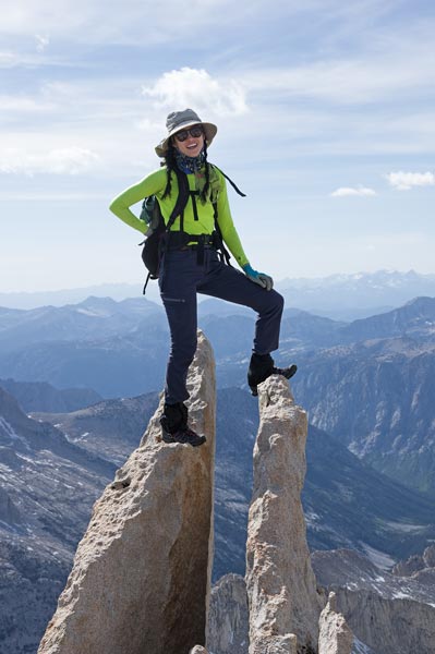
Over the col we dropped down into the Lake Italy Basin angling down on scree, snow, talus, and bedrock towards Gabbot Pass. Lake Italy vaguely looks like the boot of Italy - except as "viewed" from the inside of the earth instead of above. We stopped at a bench to stash our overnight gear and head up towards Mount Gabb. The NE ridge looked good until the top and we heard it wasn't the reported 4th class up there (harder) so opted to diagonal up towards the S side. This was tedious and we were moving more slowly now but eventually made our way up to the 13,741 foot summit to enjoy the spectacular views plus summit cookies and sandwiches. Sadly the old old register was nowhere to be found, but we signed the newer one and then headed back down.
Iris on the summit of Mt Gabb
 |
We headed down via a more easterly path cutting across some steep snowfields (that I probably would have dropped down had I been alone) and ribs and back to our gear. This worked out a little better than the way we went up. Then we headed down towards Lake Italy looking for a camping spot. We found a somewhat flat and dry place with slabs and a sheltered corner for cooking and nearby water and set up camp and started dinner - sate flavored ramen with dried cabbage and kimchi sauce plus peanuts - a pretty good combination. Our cookpot was a little too small for all of it so we cooked 2 rounds. Then it was fully dark so I took some night photos and went to bed. Sadly by now I was cold and left my puffy pants as part of my pillow rather than wearing them. It took a long time to warm up and I didn't sleep very well.
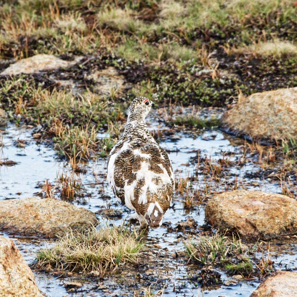
Ptarmigan (white-tailed variety male I think)
 |
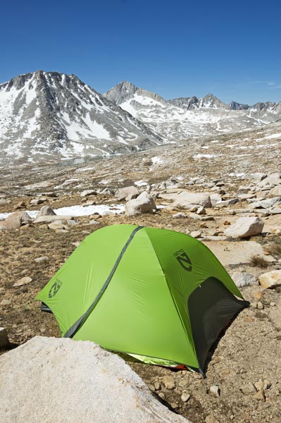
home sweet home
White Bear Peak directly above the tent was a challenge peak in 2019
 |
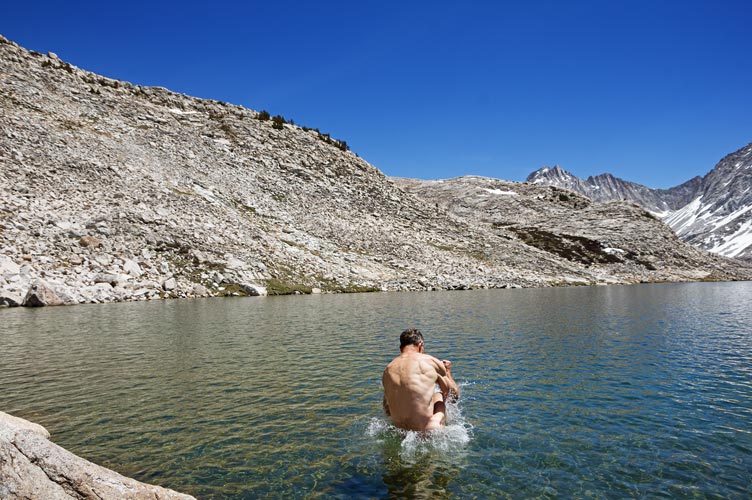
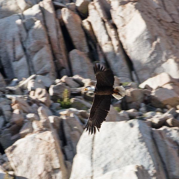
6-20-2020 Having slept poorly and cold I stayed in bed until the sun warmed the tent. Then we had a leisurely breakfast of cheesy grits and tea before heading out to climb Mt Hilgard. We didn't stay high enough on the traverse so opted to drop down to Lake Italy to walk along the shoreline use trail - plus take a very refreshing (freezing cold) dip in the lake. It wasn't very windy and the sun was hot so after drying off it felt good. Then we headed up towards the SE ridge on Hilgard. Once again we were moving slowly but finally gained the final ridge and followed it west to the 13,361 foot summit. It wasn't obvious which was the high point by observation, but the 3 benchmarks and register suggested we were on the correct point. Once again the views were spectacular. We enjoyed more sandwiches and cookies and signed the fairly new register before heading down. We opted to go straight down the S or SE Face (gulley?) on mostly scree and snow. This was pretty fast, then we contoured high above the lake and back towards camp. On the way we saw a bald eagle flying around.
splashing into Lake Italy (Iris took this photo)
 |
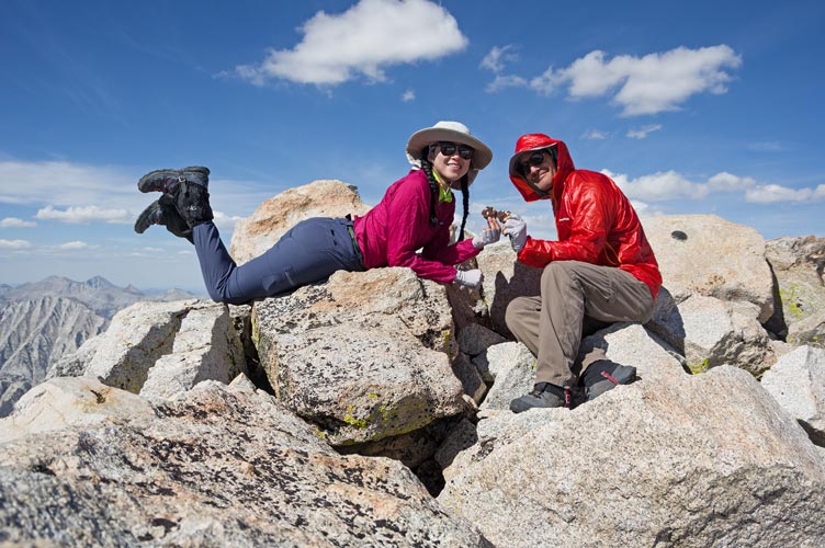
summit cookies on Mount Hilgard
 |
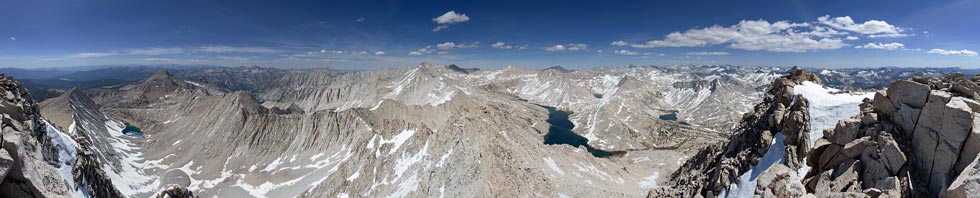
360 degree Mount Hilgard summit panorama, east is about the left edge of Lake Italy
 |
bald eagle
 |
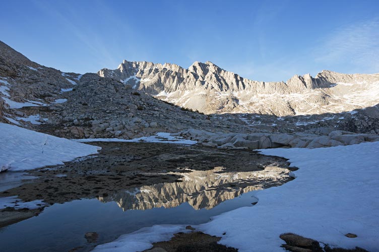
reflection of Mount Abbot in a meltwater pool
Mt Dade in the center and Pipsqueek on the right
 |
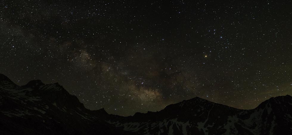
Back at camp we split our dinner of chicken and rice augmented with dried veggies and soup into 2 pots worth. This took longer but helped rehydrate and warm us. Once again I tried for some night photos but wasn't willing to stay up another hour or 2 so that Scorpio and Saggitarius were fully visible. I also wore pretty much all my clothes in the evening and to sleep and used my empty water bladder for a pillow. This made for a much better night's sleep.
night sky, Bear Creek Spire on the left, Mount Julius Caesar on the rightish center
Saggitarius is coming up left of that, Antares in Scorpio is the bright reddish star in the center right
 |
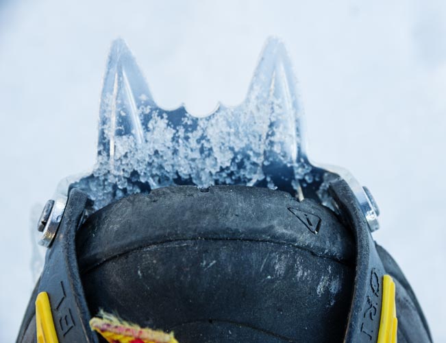
6-21-2020 We were able to get up early and just ate some bars and headed out towards Mount Abbot. We first went up to Gabbot Pass and then towards the SW Chute. To get to the chute we donned crampons and headed up the almost perfect snow to the top. Then we transitioned to scramble mode and headed up the fairly loose and dirty chute mostly sticking to one side or the other and taking care not to drop rocks down when above someone. Where there was another steep snowfield we scrambled up to the left on rocks before crossing to climb rocks on the right to the top. Here Iris encountered a death block that wiggled when she touched it. After passing it she gently nudged it with her foot and sent a hundred plus pound block tumbling down the chute - and more alarmingly the much larger rock above it dropped down too. It was interesting and a little disturbing to see how far out of the bottom of the chute these rocks bounced on their way down.
Keen boot toe and crampon
 |
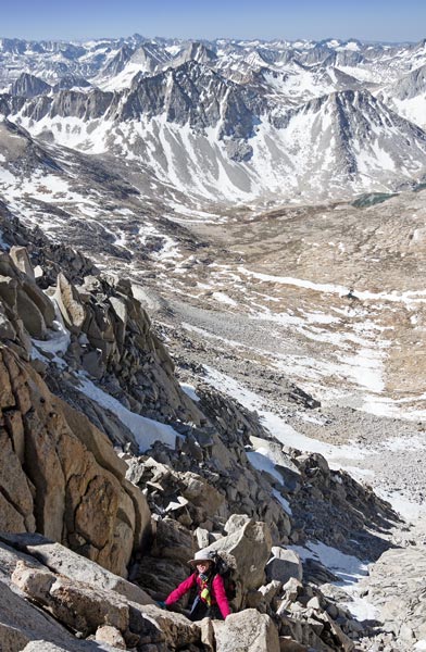
Iris almost topping out the SW Chute variation
 |
360 degree panorama on Mount Abbot, Mount Gabb to the center left is SW
Mount Mills below is to the NW below the horizon in the center right
 |
The 13,715 foot summit was only a short walk from where we topped out with another spectacular view - although not quite as nice as the previous 2 mountains because the plateau blocked some of the valley to the E. We read and signed the summit register, ate cookies and a bagel sandwich, and enjoyed the view and flat ground before we gingerly retraced our way down the chute. The snow was much softer and pretty easy to descent with only a few post hole incidents. Then we hiked back to the camp and cooked up "breakfast" of steel cut oats and packed up.
The hike out went better than I feared it would. We were able to contour a little lower than our hike in and avoid some up and down and then we were able to stay west of the snow all the way up to the plateau below N Col. The snow crossing there was mostly easy walking and then I found our footsteps to follow up to the actual N Col which wasn't very obvious from below. We stopped for the last of the cookies before getting out ice axes and heading down the snow - it was pretty soft with occasional post holes up to the crotch. Iris almost lost her boot in the snow when it came untied. Then we cut back south to stay on the snow as much as possible and followed numerous boot prints from parties descending from Bear Creek Spire (which looked spectacular in the afternoon/evening sun). One advantage of following recent steps is that you could avoid where they post holed or at least be ready for it. By now my feet were starting to get damp despite my nearly new Keen waterproof boots. This isn't very surprising considering the bottom 6 inches of my pants were soaked by the sloppy wet snow and I was wearing non-waterproof low gaiters. Dade Lake had more open water by now, but we decided a swim was contra-indicated. Below Dade Lake we were mostly on talus, this is where Iris was betrayed by her Salomon shoes which slipped on smooth flat rocks a few times. After what seemed like too much talus we hit the use trail and were soon back on trail around treeline. This is also where the mosquitos started. Sometimes they weren't much of a problem where there was a breeze or they just weren't around for some reason, at other times a wave would hit us and I could see 4 or 5 trying to bite through the back of my shoulder or arm. Fortunately my pants were loose enough to block them while I hiked and my top with a hood kept them mostly off my neck. The uphill sections of the trail were a little annoying but we made pretty good time back to the trailhead about 8 pm. There we saw and talked to a friend who was heading in the next day. Our packs had both lost about 6 or 7 pounds over the trip, some was water weight, but our food was not particularly light (lots of sandwiches and bars and not as much dry cookable food). We weren't hungry coming out although our food consumption wasn't as even as it should have been over the extended weekend.
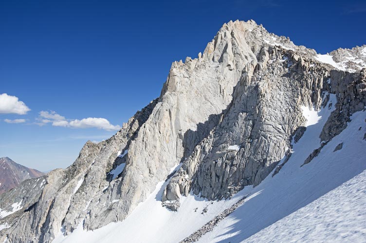
Bear Creek Spire on the way down from N Col
 |
Iris' Strava page for day 1, hiking in - map and pics
Iris' Strava page for day 2, Mount Gabb - map and pics
Iris' Strava page for day 3, Mount Hilgard - map and pics
Iris' Strava page for day 4, Mount Abbot - map and pics
No material on this page may be copied or used without permission.