8-7-00 to 8-10-00
Monday morning we (Reeve, Andy, and I) met and finished the final packing and moving stuff from the back of my truck into Andy's. Then we drove almost to Dubois and turned off up the rattly dirt road to the trailhead. We started hiking at about 11:45, with rather heavy packs. The trail almost immediately started uphill steeply. We also lost the trail quickly, but found it again easily. (it turns out we didn't start on the actual trail).
The trail (Glacier trail) continued up sporadically (with a few wild raspberries) until after bomber basin, at which point it began a seemingly endless series of switchbacks. up up up and more up. (the heavy packs were getting rather old). After the switchbacks it appeared that things leveled out, but in reality, we continued uphill at about the same grade, except without switchbacks. We continued up to a high pass that was more like a broad saddle. Then the trail headed back down, but not as steadily. We passed a number of picturesque mountain lakes, and finally camped by Star lake.
The next morning our trail went steeply downhill to Dinwoody creek (river?). This is a beautiful milky turquise blue glacial stream that looks like it came straight off an artist's palette to where it is now. We continued to follow it upstream for the rest of the day through open meadows and tight canyons. We saw a moose and some sort of weasel (ferret?) creature plus plenty of cliffs and the few remaining wildflowers (it must have been spectacular earlier in the year).
|
|
|---|
The trail ended at the morraine, and we continued on up through a monster boulderfield. At the base of Gannet peak we ran into a Nols group and got some information on the conditions from them and watched a group high on the mountain descending. Then we made camp on a gravel ridge abong the boulders. (it was actually sitting on a big chunk of ice and had a stream running under it).
We got up at 5 in the morning and headed up just before 6. I had heard a number of rather alarming reports from this mountain involving 12 plus hour summit trips and that sort of thing, so we wanted to get an early start. The snow levels were very low this year, so there was a fair amount of exposed ice on the glaciers. Andy and Reeve didn't have crampons, but there were enough steps and or softer snow to allow them to get up.
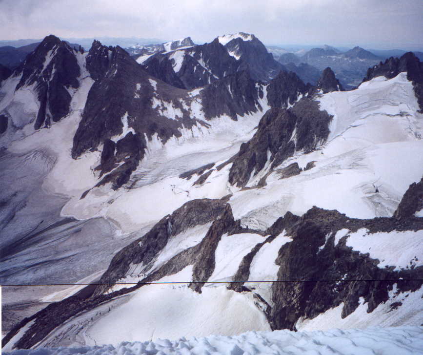
The route alternated between steep snowfields and talus slopes. It didn't take long to get to the technical crux, a "snowbridge" passing the bergschrund. This actually wasn't as scary or thin as I had been led to believe, and we easily passed it. Above it was some steep snow/ ice with decent steps (40 to 45 degrees maybe). Then more snow and talus up the south ridge to the summit. We got to the summit before 8:15 (13,804 ft highest in WY). Plenty of time for Reeve's traditional Kippered snacks. Some pictures, and admiring the views. (we could see the Tetons off in the haze). There were also a lot of rocky peaks and spires above the glaciers and glacial lakes. It was mostly cloudy, with some sun breaks and what looked like some showers in the distance.
The trip down went fairly easily. We passed 6 people heading up, and were back in camp by 10:30 am. A far cry from the 12 hour stories we had heard of. We sat around and ate some food and then packed up for the long hike back. We made it to where the trail left Dinwoody creek that night. We were all pretty beat by then, and even a jump in a very cold glacial stream didn't refresh us too much.
The next day started with a lot of uphill hiking. And continued with more and more hiking. My feet were really aching in my heavy boots, so I hiked the last 5 or 6 miles in my sandals. We got back to the car by 3pm, rather exhausted and smelly. I would have lobbied for a slower pace on the return, except the canister of fuel for the stove was nearly empty, and the other's food selection was getting a bit odd (mine was odd for the whole trip).
link to someone's pictures of Gannet Peak (plus text)
Ben had to close the Lander Bar Saturday night, so we (Ben, Reeve, and I)didn't get the super alpine start on Sunday morning. But eventually we headed out up the loop road to the trailhead. We started hiking before 11, and made fairly good time while on fairly good and level trails. As we went farther, things got a little steeper and rockier. In the afternoon we left the trail and started what looked like a long gently ramp up the SE flank of Wind River Peak. This ramp actually was pretty steep, and also had some ups and downs. (plus we were a bit tired by then)We continued up, and hit a rather egregious false summit around 6. (Now we were more than a little tired. Then up and up to the actual summit by 7 or so. (13,192 feet) Lots of spectacular views, plus a cold wind. We left fairly quickly because of the time.
|
|---|
We headed down the SE flank, through seemingly endless talus. By dark we had pretty much gotten down, but we still needed a flattish place and some water. We found this around 9. Luckily there was a full moon to guide us. It didn't make for the earlier night we were hoping for.
Monday wasn't an early morning either, but we got moving ok, and hiked downhill and found and lost the trail a few times before hitting a definite trail. From there it was a matter of putting one foot in front of the other back to the truck. We took a brief but refreshing dip in the reservoir on the way out.