Tom Grundy's Charles River Descent Page
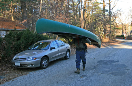
Anthony wanted to get some sort of adventure in this November while I was visiting in the Boston area, and as usual I was game. Originally we planned to head to the SE for some trad climbing, but a tight schedule, long drive, iffy forecast, last minute delays etc. finished off that plan. We opted for plan b: a descent of the Charles River. Supposedly it goes 80 miles from Echo pond to Boston Harbor. Barring unforseen difficulties, known unknowns, and unknown unknowns, we figured we could do it in 3 days. We spent a lot of time looking at arial and sattelite imagery on the web to see if we could pass the upper bits. With my dad graciously agreeing to drop us off and plans to lock up the canoe and take the T back from the harbor, we went for it starting Friday the 21st of November. Not the most auspicious date, as a cold front had just moved in. We figured as long as we didn't have to wade or swim, we could handle the cold with all the clothes we had, but we forgot about phase changes.
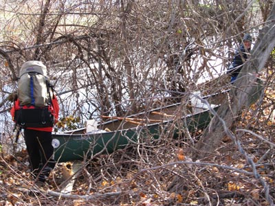
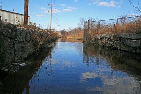
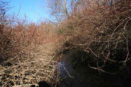
bushwhacking around the fence to the start (KWG pic)
 |
Anthony at our put in
 |
at our put in (KWG pic)
 |
Day 1
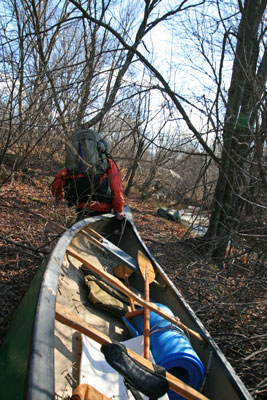
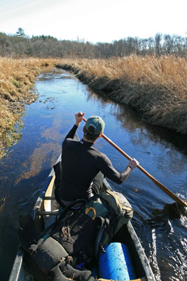
Where the infant Charles R. crossed route 85, it was more of a swamp, so we headed down to Milford, there it went under rte 16 and at least one other road in a tunnel, and emerged into a lovely polluted looking ditch. That is where we started. From there it was rather shallow and soon split and headed under a building. We walked around and picked it up on the other side. We had to walk along next to the stream to float the canoe until the flows came back together. From there we almost always could float the canoe unless there was a rocky section or a tree across the channel. The trees were quite common, and we often had to pull the canoe out and around a log. If it was warmer and we could afford wet feet, we'd probably just jump out into the water and hoist the canoe past the obstacle. Even more annoying were the sections where the brush completely covered the channel and we had to pull ourselves through the brush and downstream. A lot of bark, leaves, and dried mulch fell all over the boat and us. This was even more frustrating when a grapevine would hook on the bow and completely stop the boat. The other exceedingly unpleasant occurences were branches hanging down into the water with clumps of muck on them that would occasionally pop out into your lap or elsewhere and of course the brambles. I am hoping that what I thought was poison ivy either wasn't, or I was able to avoid it.
and we're off through the foam (KWG pic)
 |
upper Charles in Milford
 |
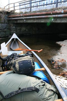
Bridge and building over the river
 |
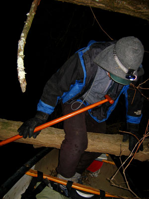
carrying the canoe around a tree
 |
Things weren't alway unpleasant. We noticed lot of balls in the water and caught in the brush and we started keeping track. Soccer balls, tennis balls, footballs, basketballs, squash balls, beach balls, foam balls, etc. Lots of them. We counted around 70 the first day. There were also pleasant sections floating down narrow but deep enough channels between reeds with the occasional ducks taking off as we rounded a bend. They exploded into the air with a disgruntled quack and usually circled around behind us, however plenty headed downstream to be surprised again.
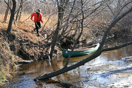
Anthony Chases the runaway canoe
 |
upper Charles brushy channel
 |
Anthony on the narrow upper Charles
 |
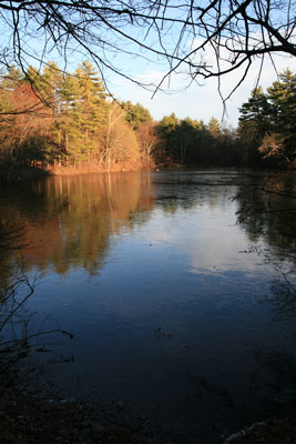
Anthony and the icy Box Pond
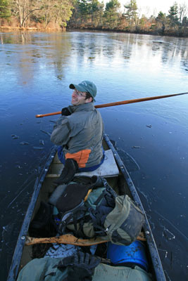 |
We were making ok but slow time when we came to Box pond. No problem, as a pair of swans laboriously took off and headed upstream behind us, then we saw the ice. At first it was amusing to crunch through the thin ice, but it took a lot more effort, then it got thicker and we decided to head to shore, but as we got close, the ice was too thick for the person in the front to get the paddle through, and the person in the back was crunching and pushing the canoe against hard ice (about 1/2 inch thick or so). Finally we crunched our way to someone's backyard and took out. By the time we had walked to a dead end on the road and backtracked and gone to the dam at the end of the pond it was about 3/4 of a mile. ugh. Luckily we didn't have any more thick ice this day, but we did have plenty more downed trees and brush to contend with.
I play with the Box Pond ice (A pic)
 |
Anthony portaging around Box Pond
 |
The iced over Box Pond from the canoe put in
 |
I climb over a low trunk while the canoe goes under (A pic)
 |
Finally some time after dark we pulled over and camped on the other side of a small ridge. Unfortunately the stove was leaking a bit, so we ended up just eating cold food (the original plan anyway). Anthony had a lot of MRE bits and pieces and some tasty bites. The MRE's claimed that nutrition was a "force multiplier", but I didn't notice us going any faster. I had a random mix of things including turkey, some fruit, pita bread sandwiches, cold cereal, and a spice cake and pecan pie. I got a little hungry and alarmed when packing, so I kept adding more and more high calorie items. Things got rather cold before we finally crawled into the sleeping bags where I finally warmed up to the point I needed to open the top a little bit and take off one of my hats. (I was still wearing 2 pairs of pants and a number of layers on my top).
Day 2
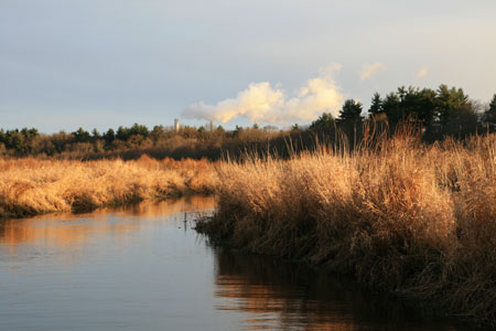
I woke up in the night to take off a hat, and thought it just might be starting to get lighter, so I checked my watch - 12:37 - ok, time to go back to sleep. The next time I remember waking up, it was actually getting lighter, so I began to get up. After waking Anthony, we packed up our stuff and were back on the "river" before 7 am. There were a few more brushy bits and logs to negotiate, but it seemed that we had passed the worst of the river bushwhacking. Soon we turned to the north and then passed under high street and the 495 bridge. Now we were mostly paddling in a very meandering 10 to 30 foot wide stream through tall reeds and grasses. One advantage of the marshy areas with no trees were no tree trunks across the channel. We portaged around a dam and building where Pearl street crossed the Charles. This is where we first saw the warning signs telling mothers and children not to eat any fish and others should eat no more than 2 a month. (this was due to high levels of mercury, chlordane, and DDT). The area after this appeared to be a disposal area for the neighborhood for years. There were a lot of rusted out old appliances and even a car. I should mention one of the interesting substances we encountered on this trip was frozen foam. Where large amounts of foamy scum collected and froze it made a styrofoam like material that was quite a surprise the first time we ran into it with the canoe.
Anthony gets ready to start day 2
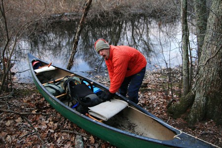 |
marshy area with distant stacks
 |
The river continued on to a Y shaped pond that was iced up. We were forced to crunch over to the side and take out in someone's back yard. From there we started portaging on roads. Someone opened their door to say hello and comment on our trip, and kindly let us refill our water bottles (and melt the useless ice out of them). This portage was about 3000 feet out past a police station and then back to the river below the dam (which we never saw). The next big icy section was populatic pond. Luckily for us, the outlet is almost right next to the inlet and we didn't have to deal with the iced over section.
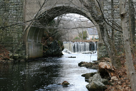
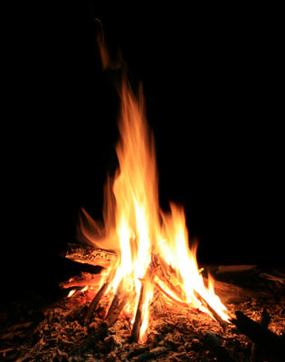
At Pleasant Street there was a small rapids that looked like fun, but not in these conditions, so we portaged around and put in on the other side of the bridge. I think it was after the 115 bridge that we started to pass "licensed shooting preserves" on either side. Anthony really didn't want to get shot, and I agreed with this sentiment. Luckily at least one of us was wearing a red coat all of the time. We heard a lot of shooting, but I think it was mostly from a shooting range, and not people hunting canoes. We stopped by the Forest road bridge for some food and to sit in the sun before it disappeared behind the trees. Unfortunately my turkey was rather icy at this point, luckily it was more crunchy than hard. We continued on well into the dark, as it was fairly easy to navigate in the open swampy meandering sections of the river. Finally we camped somewhere North of South End Pond in the woods. The ground here was somewhat frozen damp mud, so we decided to have a fire. This was nice, and also contributed to our staying up all the way to the late hour of 9:30 (it gets dark around 5, so that was quite a feat).
dam and bridge by Sanford Mill
 |
I warm up with a campfire (A pic)
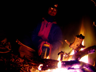 |
Anthony enjoys the campfire too
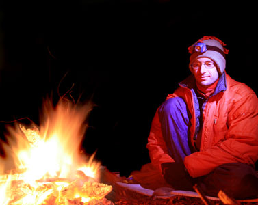 |
ahhh ... nice warm campfire
 |
ice on the canoe in the morning
 |
Day 3
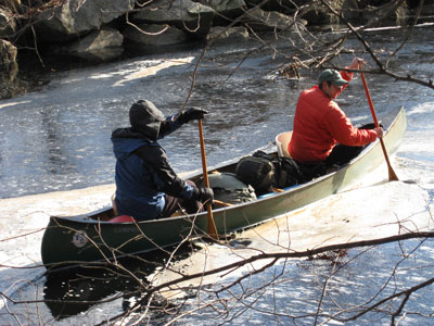
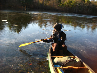
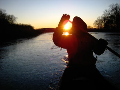
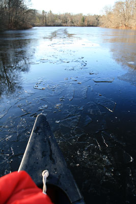
Once again, I woke up just as it was getting light. This time we broke through the ice to get back on the river around 6:45. Unfortunately it had been clear and cold overnight, and there was more ice on the river. The areas along the shore that were frozen had extended 4 or more feet, and there were rafts of ice floating down with the current. In places these extended across the entire river, and trapped more rafts as well as freezing tighter themselves. We were able to make decent headway until the ice got to be about .25 inches thick, then it was a real pain as the person paddling in the front had a hard time breaking their paddle through the ice. It was incredibly loud too. We had to punch through a number of iced across sections.
I paddle through ice at sunrise (A pic)
 |
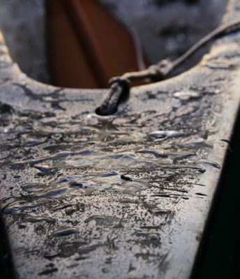
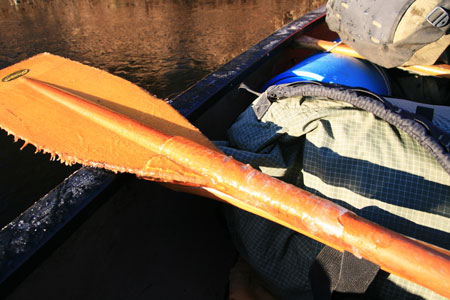
The paddles were getting damaged and icing up
 |
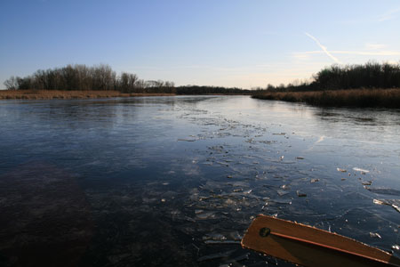
There was usually a clear channel until we got to a wider slower section approaching the dam at Pleasant Road. There we busted through a lot of ice thinking we could see clear water ahead on the right. When that turned out to be smooth thicker ice, we crunched over to the left bank and pulled out in a back yard (once again we picked a yard with canoes, as we hoped they would be more understanding). There we had a relatively short 1500 or 2000 feet of portaging along Eliot road and through a park next to the dam and tailrace.
Path of broken ice
 |
I get a teeth freeze from a frozen apple (A pic)
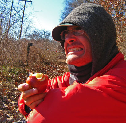 |
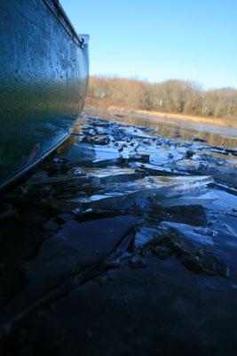
We joked that much of the trip was like a fine homes and historical tour, with old bridge abutments and other signs of early development along the river combined with many attractive homes along the river, some of which were very large and fancy. I imagine some of them had fantastic views out of their monstrous picture windows. We stopped for lunch/snack, and I got an ice cream headache from eating a mostly frozen apple. Anthony explored the joys of MRE crackers, peanut butter, and hot sauce. The next hitch was another dam to be portaged after South Street. We shot the next low head dam (by low I mean 6 inches) and headed on past Needham. Shortly after the I-95 bridge, we decided to take a shortcut to avoid a large meandering loop. We didn't know if this would work, and in fact once we had hit the river again we thought we were still on the bypass and were trying to decide which way to go. We found a takeout by a park, and the park map suggested we were in fact on the Charles River. (I later learned this shortcut is actually "long ditch" which was constructed by settlers in 1654). We headed downstream into increasingly dense ice. Finally after about a quarter mile of icebreaking we could see that the "open" water near the next bend was just a small pool, and this ice was getting thicker. By bouncing the canoe up and down I was able to create waves which cracked the ice in a large enough pool of open water to turn around, and we headed back to Millenium park. There we were able to call my father who graciously came to pick us up. By the time we took the canoe back, it was just about dark and getting cold again.
Another trail of broken ice - end of the line
 |
broken ice and bow
 |
All in all, this was a nice little adventure, although we didn't manage to succeed in our goal of descending to the Harbor, we did manage some suffering and exploration as well as see a good bit of the river. I don't know if we would have made it without the ice, but it would have been close. We figure we canoed somewhere around 50 miles of the river and had less than 25 miles to go. The reservoir near my sister's house was frozen solid the next day despite warmer temps, so waiting one day wouldn't have helped much. We counted nearly 140 balls of all sorts along the river as well as plenty of other trash from cars, appliances, plastic bottles, cans, and general trash. We also saw 2 boats, one floating against a tree jam, the other half sunk in the middle of the channel. There was a lot more trash in the upper reaches though. I don't know how many times we had to get out of the canoe to pass obstacles, but probably around the mid 20's or lower 30's. We saw quite a bit of wildlife, mostly ducks, but also geese, swans, gulls, great blue heron, hawks, kingfisher, grouse?, muskrat, beaver, deer, and one unidentified fish.
You can probably check out more pictures on the electricant pages here
Electricant picture gallery