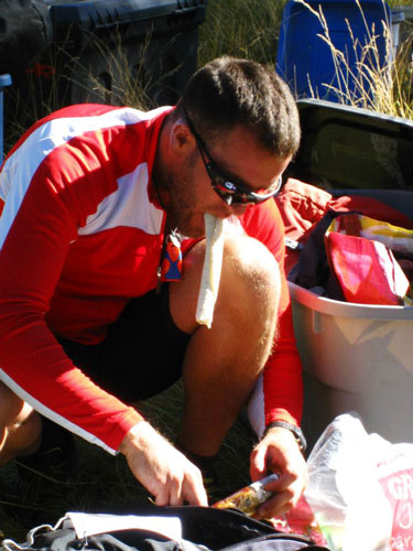
I swiped this pic from the Bend Racing facebook page.
I have participated in many adventures with the Yogaslackers - even before they were the Yogaslackers. One of the things I hadn't done was an adventure race. There are a number of reasons for this omission. These include the cost, the effort, the gear, the fact that I am slow, and my general belief that I'd rather take a bit more time, take more photos, and generally enjoy myself more on a similar adventure. All these excuses still hold true, but I have always been a little fascinated with the exploration of limits and feeling a bit left out when the others reminisce about the suffering. So when they hosted a race around Bend and I thought I'd be free and relatively nearby I decided to give it a try.
My partners in crime would be 2 other Yogaslackers, Raquel and Shawn. None of us had done an adventure race, although we were not strangers to physical effort or suffering either. Things gradually came together and we joined up in Bend the day before the race (Raquel and I were there a day earlier, which allowed us some acro and slackline playing). One advantage of having a number of friends who do adventure races is that we were able to borrow a lot of gear. Sam lent me his awesome Ellsworth full-suspension mountain bike and I also had a lightweight inov-8 pack, some bright lights, and some other bits and pieces of gear. We made out best guesses about what we would want to eat and wear for the race although we really were just guessing. Our name for the team was SrekcalSagoy (Yogaslackers backwards) - eventually we could usually pronounce it, although it took a bit of practice - we had 36 hours.
At the pre-race meeting Friday evening we got the maps and copied some of the checkpoints off of the master-maps. That gave us a better idea of what to expect and we re-packed a few things and I tried to come up with a plan of attack as far as what route to take (there were a few roads that were off limits, but otherwise we had our choice of roads, trails, and bushwhacking to get around). I think the total course had over 200KM of biking and 30 km of trekking (although we didn't have to do it all) and some packrafting and caving and a few other little surprises. We didn't get to sleep as early as I would have liked on Friday evening, and Saturday morning came very early - around 4:30 am. We would all regret only getting about 5 hours of sleep.
We got a bit of food into us and to the check in around 5:10. At 5:30 we started biking to the actual start - about 6 or 7 miles away. The race officially started around 7:15 with a mad scramble to try to count out various words on a number of interpretive signs. We weren't very aggressive in getting close to the signs or good at counting. By the time we finished this and got onto our bikes we were in last place. DOH. We headed down the road and when we hit the paved road our spirits were raised by another group coming down the road towards us. I am not sure if they took a different road or turned the wrong way at first, but it was uplifting to see we weren't completely behind. They passed us as we turned off onto a dirt road, but we felt smug as we turned off onto a singletrack and about 8 other people headed the wrong way up the road. Some of them recovered and passed us quickly (the theme for the day - people passing us again and again). I made one navigational error that resulted in a little more up and down but not much more distance after one check point, and we should have immediately abandoned plans to go down a road that had been decommissioned (plowed). Luckily it was pretty easy to travel through the woods along it. All this time we had been trying to stay on a hydration/food schedule. Every 15 minutes we drank and every 30 minutes we drank some more and ate something. We actually managed to keep this up for nearly 12 hours and continued it more sporadically after that. As we biked along Shawn would yell out "drink" or "eat" at intervals. If nothing else it did provide a sensation of passing time and probably helped prevent dehydration or bonking.
| |
|---|
The next stop was the transition to the packrafting/trecking leg. We weren't particularly good at the transitions. Partly because we were just slow, and partly because we weren't particularly efficient or organized. Eventually we were ready to put in - and then upon a comment from a race organizer I reconsidered the map and realized a very short walk could save us a big oxbow - so we trotted a hundred yards and then put in. Raquel and I were in my raft. She had hand paddles and I had a regular paddle. We were able to move much more quickly than Shawn in a scout, so we tied together and motored down the river. I was having trouble spotting the first checkpoint 'til I read the instructions and realized it was just what the mph was on the speed limit sign. The next checkpoint was reached by climbing up a bridge support. We did that one very quickly because Raquel could hold the raft while I climbed up. Then we skipped the next one (as it was along the trail we would return on) and continued on past a number of people stopped to get it. I think the packrafting leg might have been the only leg where we actually passed a number of groups. Once we got the final packraft checkpoint we rolled up the rafts and started back towards the bicycles. This is where the hydration bladder in my pack that leaked a little dumped a few cups of water onto my back. Somehow it had gotten twisted around in the pack. Luckily this happened during the warmest part of the day and I still had enough water to prevent dehydration. We power-walked up the hills and did a little shuffle-jogging on the downhills. The trail got a little indistinct where we cut back to the river to get the final checkpoint, but it was an easy location to find. From there we seemed to make all of the correct turns compared to another group that ran past us 3 times. Back at the checkpoint we had another fairly slow transition back to the bicycles.
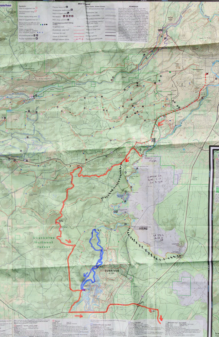
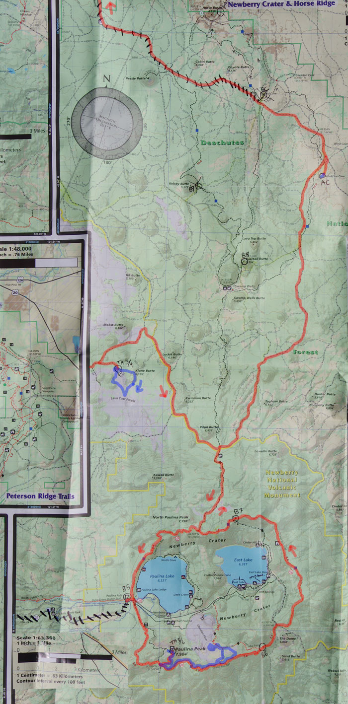
The next bit was a few miles of biking on paved and fairly solid gravel roads. One checkpoint was up above a quarry - made a little spicier by the people target shooting there. (this is the end of Map 1 below) Then there was seemingly endless washboarded gravel roads with a little "break" on a very dusty road and up a steep hill to the top of a butte (a cinder cone). Then we continued back to the gravel road and up to the "lava cast forest" (this is on map 2 below) for another trekking section. We were reduced to walking up some of the steeper road sections. It was a nice break to be able to stretch our legs to get the checkpoints here. The first was on top of a high hill (another volcanic cone). When we got to the edge of the lava field I was glad to be able to put on long pants for the bushwhacking. There was a lot of broken aa lava fields to cross to the next point - I was glad to have my bike gloves on, although I should have had my leather gloves with me too. I realized my extensive talus and scree experience in the Sierra and other mountain ranges did allow me to travel a little faster and more securely on this sketchy terrain. The final checkpoint here was at a saddle between two peaks. We angled up a little early and came to a saddle without any checkpoints, but a few hundred feet NE led to another saddle with the checkpoint. By now it was nearly dark and we headed across another lava flow towards a trail. It wasn't quite where it was marked on the map (by my reckoning - a theme for me as a navigator), but it was close. I am not sure I have ever been as happy to get to a paved trail. We took the trail back to the bikes and rehydrated and prepared for the next biking leg in the dark.
It is here that I probably made my biggest tactical error - taking a trail up over a mountain rather than dirt roads that mostly went around it - and a little bushwhacking. (I had considered that, but couldn't tell how the bushwhacking with bikes would be so opted for the sure path). We had now been pretty much on the move for over 12 hours and were definitely not fresh. We ended up walking some more uphills, especially when they had lots of loose soil. Much later we got to the turnoff onto the trail up the mountain. It had lots of downed trees we had to pick the bikes up over as well as steep bits we walked. Then there was a long section across an endless pumice plain. We had to walk that too. As the trail continued up from there I thought it was heading the wrong way and started to get concerned we missed the turn. I ended up scouting ahead and decided it was still the trail we wanted. At this point there was another group we were playing leap-frog with. We caught up with them at the intersection where we took a short break for some food. A few flakes of snow were falling - definitely not something I was expecting on this race. The downhill was a bit frustrating because Raquel was unnnerved by the loose dry soil (of which there was plenty) and often went much slower than Shawn and I would have. At other times she zoomed down things as fast as I would want to go. It was nice to not be pedaling and walking uphill though. As we neared the bottom the temperature dropped a lot. The next checkpoint was at a waterfall overlook on the N side of the creek - the problem was the trail to it was one-way - going towards us. We finally decided that anyone coming up the trail at midnight would be able to deal with us coming down it- especially with the long range warning of the headlights. This checkpoint involved scrambling down to the base of a waterfall and finding a coin each there. We all put on raingear for this. The scrambling wasn't bad, but I looked around for a coin for a while. Luckily Sean could see them (I think that the spray all over my glasses did not help). We were still cold when we got back on the bikes and were a little confused with another conflict between what the map said and what was on the ground. Eventually we found a trail (where there was supposed to be a road) and headed on up towards the summit of Paulina. This was about 3 miles of continuous uphill. It was also raining - sometimes hard, sometimes just a mist. Luckily we already had our raingear on so there was no need to stop to put it on. I saw a few happy frogs hopping across the road. We were not so happy. Sometimes slowly grinding our way up the road, sometimes walking. Jason drove past and gave us encouragement though. I think we got to the top shortly after 3 am. I actually felt pretty good, especially considering I had been on the go for about 20 hours and it was 3 in the morning and raining off and on - mostly off by now. I headed down a trail a bit to grab the trekking map while the others were eating and getting ready for the next bit (or sneakily sleeping for 10 minutes while I wasn't looking). It was awfully nice to get some hot ramen noodles and coffee here as it got chilly fast when we were no longer moving uphill. We decided to completely avoid getting the packraft checkpoints and only try to get the one closest point (we had to get one trekking point, the others were optional). It took a bit of cajoling and whip cracking to get everyone moving (and I wasn't setting any speed records myself). I think we started off around 4:15. We headed about 3/4 mile down the road before turning off on a trail. The horizon was starting to get light by the time we were supposed to leave this trail. Somehow we totally missed the trail intersection though. We overshot less than a km and after some indecision and map staring headed down through the woods and across a pumice flat to pick up another trail. That was my last major navigational error - it probably cost us about 30 minutes and a lot of uncertainty.
We ran into another group coming from the checkpoint and they gave us good beta about where to leave the trail but I completely misunderstood their description of where the checkpoint was. It was supposed to be on the rim of the obsidian dome crater. For starters the crater was pretty indistinct - it was more like a jumble of trenches and towers and heaps of broken glass. Pretty cool terrain, but not the sort of place one really wants to scramble around for 40 minutes looking for a checkpoint. At least it was getting light by now - in fact it was a pretty nice sunrise - the early morning and evening light had an ethereal quality from all the smoke from forest fires. Raquel was near the edge of the dome and another group just scrambled up and then back down, so she knew it was close. She called us over and had found it before we made it back. At this point we realized there was no way we could make it back and leave the checkpoint by the 9 am cutoff. There was nothing to do but head back anyway but I was pretty bummed. We passed a number of teams on the way back - most were mountain biking down the trail we were heading up. This included the lead team with Chelsey and Daniel. We learned that they had dropped some of the final points and there wasn't a 9 am cutoff. Back at the bikes we loaded up what we would need for the rest of the race. Shawn's knee was hurting and he didn't know if it would keep getting worse. I took off a bunch of clothes right before we left. This was a big mistake because the first mile was all downhill and mostly into the wind and very chilly. I was actually glad for the uphills so I could warm up. Unfortunately Shawn was hurting and going slowly on the uphills and Raquel was fearful of the loose sand on the downhills and went slowly. I found this a little frustrating but figured if we could maintain 4 mph we could still make the 36 hour cutoff. When we passed the trail I missed in the dark I hadno idea how I didn't see the signs. It was about 5 in the morning and I was pretty tired though. Most of this trail (the rim trail) was pretty fun singletrack with a long stretch of jeep road too. Shawn's knee continued to deteriorate and he had to walk less and less steep uphills. Around 11 am he decided that it wasn't worth it to continue abusing it and he should quit. We still had to figure out what the best way to do that was since we were sort of in the middle of nowhere. It appeared that continueing on around the rim trail and back to the paved road near the waterfall would be the easiest. He had sporadic cell reception but made the call. Raquel and I were going to continue on despite officially being disqualified. We stopped a few times because Raquel thought it wasn't right to leave Shawn alone, and each time he caught up he wanted to know what we were doing sticking around. Eventually we reached the turnoff and headed down the trail we had come up in the middle of the night. It was a lot easier to descend in the day although there were a bunch of nasty rocky bits and lots of logs to lift the bikes over. When we got close to the pumice flats we ran into a group that was heading back up having crossed the flats to a different trail. We assured them that we had come up this trail in the dark and were able to find the correct trail out the other side of the flats. The rest of this trail would have been a lot of fun had there been no trees across it (but there were, so it was a bit tedious). Finally we hit the dirt road.
The dirt road soon gave way to a gravel road. It was downhill too, so our speed increased dramatically - so much so that I was quite chilly again. We decided to skip the last checkpoint and head for the cave (Raquel didn't want to go uphill as the last checkpoint was on top of another cinder cone) - I later realized I could have just headed up to the top alone since we didn't have to stay within 100 yards of our teammates anymore. I guess the lack of sleep was effecting my thinking after all. In any case it was nearly downhill all the way to the cave and we made pretty good time getting there at 4. We were the last group there, so we were told to "clean" everything (there was pirate booty in the back of the cave). We headed down in and squirmed in through the giant fallen blocks. Then it was a typical lava tube cave, like walking through a subway tunnel on a very rough lava floor interspersed with scrambling over blocks fallen from the ceiling and one stretch requiring crouching. Eventually we got to the back of the cave where there was a chest full of coins illuminated by a LED light and a checkpoint. We cleaned that and headed out. We were in the cave for over an hour despite not really dawdling (but not running either). From there it was 4 to 6 miles to the finish line, but we (with Sam) headed back to the house. This was no mean feat as it involved about 15 miles of biking. We were rather tired and I was having trouble keeping up with Sam (Raquel did a better job of drafting, or maybe she was just holding out extra endurance). I tried to put how far it must be out of my mind and just kept pedalling. Things got a bit easier - well, we went faster - once we hit pavement. We were less than 1 km from "home" when Raquel got a flat tire. Luckily we had a spare tube and pump (Shawn had a pump and spare tube too). We replaced the tube and then headed the last little bit back. I think we got back around 6:30 - so truly 36 hours since we had rolled out the previous morning.
I took a brief shower - really more of a rinse. Then we drove over to the Goodlife Brewery where the end of the race "celebration" was. We recounted tales, ate some food, and there was a brief awards ceremony. The winning team finished the entire course around 2 pm. They also got all of the checkpoints. There was also some nice "booty" (I got a hydroflask among other things) and I drove an extra vehicle back. Then I ate some ice cream and slept. This was very nice. My eyes really hurt. I think this was partly from just having them open too long, but also there was some smoke in the air and an awful lot of dust - especially as I was rarely in the lead on the bicycle.
The next day I was sort of a zombie. It would take me a long time to actually accomplish things despite making numerous starts. I gradually managed to check my phone, clean and pack my raft, sort and return the borrowed gear. Get my camera gear back from Sam, etc. That evening there was an acroyoga class at the nearby circus center. I was definitely a little more tired in my legs than normal, and the Yogaslacker conditioning was definitely harder than normal, especially on my shoulder which was a bit injured already and feeling the miles of biking with a pack. (my injured ankle didn't seem to bother me much in the race, although I was pretty careful with it on the treks and didn't run very much).
Although it might sound like I was an adventure racing machine and my lowly teammates prevented me from trouncing everyone and dominating the course this was far from the truth. In fact they often had to wait for me while I stared dumbly at the map and tried to figure out which way to go. Also although I could keep up on the bicycle I wouldn't have gone much faster on my own. As I have often asserted, I can go long distances and carry loads uphill SLOWLY. Unfortunately in any sport that is racing, slowly isn't always good enough, although with longer races there is something to be said for being relentless even if not particularly quick. It was fun to have good and enthusiastic teammates, and they definitely helped keep me motivated, especially when it was cold, and dark, and rainy and my energy was flagging.
Facebook page for Bend Racing - this might not work so well w/o logging in, but it might. Take a look at the scenery and other pics posted - I swiped the pic of Shawn from here.
Eventually someone should make a video with some of the footage Sam took, but it is entirely possible that I will post this before that happens. I'll try to put up a link when I can though.
Here are some maps. The first one includes part of Bend in the upper right. The red dots are the ride from the Goodlife Brewery to the start. Then the red lines are biking, the blue is packrafting (if it is in the water) or trekking - on land (or caving - although I have no idea of the direction the cave actually went, probably downhill). The 2 maps aren't the same scale, but if you can see the pale blue squares - they are 1 km on a side. I have a scale on the second map. I put a few arrows to show the direction we were going. There is about 12 or 13 KM missing in between the 2 maps and one checkpoint on top of a cone.
 |
|---|
 |
|---|